Showing posts with label Exploring Tsolyánu. Show all posts

Saturday, January 11, 2020

The Tower of the Arch-Mage: Exploring Ngála - Part 2


The Wizard of Zao,
One of my favourite novels...

Often when I visit the local dollar stores I am looking for stuff I can turn into other stuff. Equally often, however, I never get the time to actually execute those plans. Today was one of those rare instances!
I had spotted a Christmas decoration in the remnants of the Xmas section. It was a cone shaped wire thingie covered in gold glitter and a few coloured beads. I guess it is supposed to be a Christmas tree?
I decided it would make a nice frame to build a tower roof around so I bought it. Afterwards I decided I should have three but now all the Xmas stuff seems to be cleared away. Moral: buy it when you see it, don't dither.
So I had decided to make the roof of a tower. The tower of what? For what? For whom? I didn't know. I still don't know! 
For purposes of this blog post I am going with the working title: "The Tower of the Arch-Mage". 
Who is that, you ask? I don't know that either, but my first guess is the Wizard of Zao, that being a favourite Lin Carter book of mine. Not sure if he will have green skin though...
Actually, a thought: perhaps this is the guy with the walking palanquin from my last Ngála post (Part 1 - see previous).
So, some dollar store crafting: a Christmas decoration, some packing material from something I bought online, some duct tape and a few staples... 

1) First I covered the cone with duct tape.

2) I discovered some packing material that was flexible and easy to cut...and not
too thick. Suitable material for tiles?


2) I tried stapling on the first few strips, but quickly switched to duct tape.

3) Somewhat belatedly I realized that I should be cutting the strips into curves!
4) The last step is to cut into the edges of the strips to make the individual
tiles.

Compared to a 28mm figure they are quite large! Which is why they have lasted so many millenia!

5) Finishing? A coat of Gesso, maybe?
Cost so far:
Christmas decoration: $1.50
Packing material: free (somebody sent it to me).
Duct Tape: $4 for the roll. I used about 3' maybe. Maybe 5% of the roll.
Staples: about a dozen (from "stock").
Time? a little over 2 hours, including time to take pictures and compose email.

A Note About Ngála

When I went to put Part 1 of this series up on other forums, such as the Lead Adventure Forum, or The Miniature Page, I realized that nobody would have any idea what I was rambling on about. Or, at least, many people wouldn't. So I wrote a bit of a blurb as a sort of intro. But then I realized that I should have included that in my original post. I never got around to editing that, so here is the blurb, belatedly, for your enlightenment and enjoyment. ;-)
Ngála
An ancient city on Tékumel. I tried counting how old it is. The current empire, the Empire of the Petal Throne or Tsolyánu, is also known as the 2nd Imperium and is over 2000 years old; the empire previous to that was Éngsvan hla Gánga, "the Mighty and Powerful Empire" - the Empire of the Priest-Kings, which lasted 3000 years, give or take. Before that was the 1st Imperium, Nayári's Empire. That went on for 10,000 years after her death and Ngála was old even before Nayári founded her empire.
You can see it up at the left edge of this map...

Of course, after 15,000 plus years nothing could possibly be still extant above ground, right? Yes, well, sure, if one were talking about an ordinary city. But Ngála was no ordinary city, and now is no ordinary ruins. We know the Temple of Hriháyel, the Dancing Maiden of Temptation, uses at least parts of the site for summoning demons so it is not a great leap to think the city as a whole is special.
Furthermore, there are probably multiple iterations of the city, possibly some distance apart as the city developed historically. My "take" is that there is 
1) Ngála, the ruins where the Hriháyel priestesses carry out their rituals. This is on the Nyelmáyel river, the River of Dreams. At least in My Tekumel, it is! Your mileage may vary, as they say. I see it as a sort of Tékumel version of Deadwood, or Bartertown, or the Five Points area on NYC in the 1800's.
2) Then there is Pála Ngála, literally "Old Ngála", which sprawls further to the West and comprises many of the older incarnations of the city spread over a large area.
3) Finally there is "Greater Ngála" - I still need to look up this would be in Tsolyáni.  ;)   Greater Ngála exists beyond this realm, in the realm of sleep: the Dreamlands. Greater Ngála exists as it was at its height, or as some version of it at its height, or possibly all versions; the priesthoods are still debating these points.

Saturday, December 7, 2019

Exploring Ngála - Part 1


An almost bare table...


My usual ground cloth...


Some strips of old roads; a lucky a flea market find...


A broken old Chess set...


Hecho en México! 
These are, I think, quite common in 
tourist traps down in Cancun or Acapulco...


I found on mine ebay. Most versions were close to 
$200 US but this one was damaged, and with an 
incomplete set of figures, so I got it for a good price...


When it arrived the board practically fell apart in my hands!
Which was a good thing! I might not have wanted to do anything to 
it if it had been undamaged...


I could use it with the chess board upright, but I think reversed, 
as a platform is more useful...


Here is my test layout with bits from a variety of sources: 
Aztec-themed Terrarium ornaments, SE Asia statuettes, 
and unpainted resin bits from Acheson Creations.


Other bits are from Stone Mountain(L) and Fenris Games(R). 
The lanterns and statue are from Petsmart. 
The chess men are from yet another Aztec-themed 
chess set I own. One of three!


I think the city-scape should be cluttered. 
A mixture of Acheson Creations, 
Flea Market finds and Pet store products.


And it should be all overgrown. Still need to do that bit...


The strange contraption with legs is actually a
candlestick I bought in some tacky knick-knack shop. 
In my game it belongs to some Lord: his walking palanquin!


Chess men arrayed "terracotta soldier" style...


I need either taller platforms or buildings to put on the pyramid base.


And stairs leading up onto the platform...


And there should be lots of different levels. 
Ground level should not be so flat!


At left, I have added a Sarku-style crest to my Petsmart Buddha...


The platform at left is a Petsmart offering from a few years ago. 
I can't believe I only bought one! 
Why wouldn't I buy two so I could put them back-to-back?
Must have fumbled my "Bargain Hunter" check...


Note that the statue has undergone a bit of facial surgery. 
Gone are Buddha's serene features, 
replaced with a head from what is I believe a Gulper Eel 
from the Safari Ltd, "Deep Sea Creatures" Toob.
I call him "Prince Caspian"...


Lots of work to do...
Platforms to make!
Columns to make!
Sets of stairs to make!
Chess figures to convert into statues!
etc.
etc.
etc.

(And I haven't even used any of the Zombie Quadrille stuff yet!)

Monday, January 14, 2019

Digitizing Tékumel, part 24: The Mssúma Delta


The Mssúma Delta

Latest work: I've taken my earlier attempt at sketching the delta and added my latest efforts at Nisuél. If you enlarge the image you might be able to get the hint that the splash of colour at Nisuél is in fact the cover image that I am tracing.

My older rivers are much wider than that in the cover painting. At least, as I currently have that scaled. Nisuél is about 600 meters from north to south along the river, measuring between the wall bastions. So the Nisuél map symbol shown above is about a kilometer across.

My initial canals now have to be re-thought out and re-drawn. And I need to decide how many other larger clan holdings are in the delta - and which clans they are!

The Red Marshes I've blogged about before >>> Here. I have to decide how large to make them...and how many forested areas to add as hunting reserves.

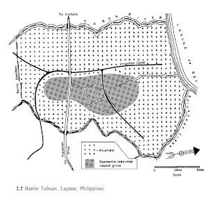
I also need to re-read the "Anatomy of a Peasant Economy" (LINK) to give me a better idea if I've scaled my Nisuél correctly. I can compare the real world example with the density shown in the artist's impression.

Edit: I just found a YouTube video from 2015 of  "Pila Laguna - Tansa and Tubuan".


Lots of footage of rice paddies and raised secondary roads; just ignore all the modern elements.


Barrio Tubuan, circa 1978

Saturday, December 22, 2018

Nisuél, Seat of the Clan of the Golden Sunburst - Part 2


Gylph of the Clan of the Golden Sunburst
(Artist unknown)


Nisuél

Original Source: 
Thonburi 1767-1782
Artist: Suthichai Ritthapatichai
Muang Boran Journal
Vol. 43 No. 4 October-December 2017

Plodding ahead with detailing the Mssúma river delta, starting with Nisuél, seat of the Clan of the Golden Sunburst, I have started to identify some of the location names. Don't forget to use the tags to find the rest of this series, and the overall "Exploring Tsolyánu" series.

Ever since I happened across this artist's impression of the city of Thonburi (Thailand) by Suthichai Ritthapatichai I have become more and more convinced that this is what the Mssúma delta looks like. Thonburi is even described as being a "canal and garden (or park) district". Which matches pretty much with Professor Barker's description of the delta being "...the Produce-Garden that feeds Jakálla..." and how it is "criss-crossed with canals and secondary roads." 

Nisuél amounts to a good-sized village. It is located on the Dhu’ónin River (Golden River), one of the many distributary rivers that thread to-and-fro across the Mssúma river delta. Between them are networks of major and minor canals, creating a patchwork of fields and ponds, with woodlots scattered here and there, and secondary roads weaving throughout it all as best they can. The population of the delta is pretty dense, mostly employed in agricultural practices. It is a pretty safe district, with Tékumel's more dangerous denizens kept far away by vigilant warders and a millennia old policy of extermination for any that stray too near.

I've done a bit of research on the Clan of the Golden Sunburst. I've looked up personages in the various sources, principal of which is always the "Hardison Guide", as I call it. One thing that bothered me was that Alva lists the Clan Patriarch as being named "Nisuél"; bothered me until today, that is, when it finally dawned on me that they were just following the long standing practice used by the legions of the Kérdu taking the name of the traditional Kérdu. i.e. "Sérqu" is passed down through the ages, from one general to the next. Indeed, the Hardison Guide mentions that the "17th Sérqu" was a member of the clan. So I am reconciled with the idea that the Clan Patriarch is called "Nisuél" even as it is used for the community itself.  

If you click on the above image you'll see I've used this in my attempt at naming the features on the painting. 

Nisuél's Manse - which is the principal residence of the sitting Clan Patriarch. 

Also shown is the Bastion of Sérqu, "Swath of Red", a reference to that 17th Sérqu mentioned in the Hardison Guide. A similar defensive work is at the southern end: the Tower of Kokún Vriyón, named after an Éngsvanyáli "Hero of the Age". 

Other features I've tentatively - this is still only a first draft - identified are:

The Channel-Master's Station and the Canal-Master's Lodge, two of the clan officials charged with the smooth running of the Clan's business. I suspect the Channel Master out-ranks the Canal Master. 

The Palace of Serene Repose, a guest-house for noble visitors.

The Domicile of Iron, one of the clan's own Temple and/or Mausoleums.

The Mansions of Resplendent Glory, the main clanhouse complex. 

The Halls of the Exhalted, more Temples and Mausoleums, including monuments dedicated to the Clan's greatest ancestors.

The Guild of Iron, one of the subservient clans I've identified, this being hereditary warriors and bodyguards. I don't think "Guild of Iron" has been used before, and while there are no guilds as such, the term guild has been used: the Temple of Qon's "Guild of those Who Repel the Dark" (Source: Mitlanyál, Vol. 1).

The Barracks of the Guild of Iron, barracks for the Household Guards, almost all members of the Guild of Iron clan.

The Palace of Heroes, being more palaces and monuments to the Clan's glorious past. Note that I think clan apartments would be scattered among these complexes for senior members of the clan to reside in. 

So that is my start. As I said, a first draft. Coming up with extravagant sounding names ain't easy you know! ;-)

Sunday, December 2, 2018

Best Kept Secrets: "The Economic Aspects of the History of the Civilization of Japan", Vol 1


I've blogged about this before. I had meant to expand on my initial post once I received my print copy but I never did, sadly. Need to follow through on that!

But that isn't why I'm blogging today. I just discovered a digitized version online! Yay!

Vol 1:


Originally published in 1930, I guess it is out of copyright now. 

Edit:


Saturday, August 4, 2018

Nisuél, Seat of the Clan of the Golden Sunburst - Part 1


Thonburi 1767-1782
Artist: Suthichai Ritthapatichai
Muang Boran Journal
Vol. 43 No. 4 October-December 2017

I discovered this image on the Patreon page of one Munkao: 


I'm not sure how active he is anymore, but even if you do not subscribe you should take a moment or two (or three!) to browse his public posts. There is a lot of useful stuff there!

My first thought on seeing this image was: "Wow, that is what the Mssúma river delta must look like! And that is the village of Nisuél!" 

This is an area I have been trying to draw as part of my Digitizing Tekumel project.  I know it to be the seat of the Clan of the Golden Sunburst from the third solo game-book: "Beneath the Lands of Tsolyánu". (The one with the green cover.)


These books are Excellent!
Highly Recommended!


Nisuél 

Headquarters of the Clan of the Golden Sunburst

Located about 100 tsán north of Jakálla in the heart of the Mssúma river delta.

The village contains more clan houses than just those belonging to the Golden Sunburst; there would be subsidiary clans, hereditary vassal clans, perhaps a bodyguard clan, or a boating clan, and similar. Looking at the painting, I would declare that the large white buildings were Golden Sunburst clan houses. The other large buildings are those of subsidiary, or vassal clans closely tied to their senior clan. The lesser buildings are perhaps still other clans who are not tied to the Clan of the Golden Sunburst but whose clan business requires their presence. And of course there are workshops, storage buildings and the like as well. The buildings near the fields are not clan houses of course but are workshops or storage areas, or are intended to provide shelter to "Field Watchers" in the outlying areas.

The large river is one of the distributary rivers branching off the Mssúma river as it reaches the delta. There are dozens such rivers of varying size. Nisuél is on the Dhu’ónin River, the Golden River. 

Other river names I've come up with are:

Festival River Gohóimu River
Fever River Ubó River
Fear River Ssünrü River
Mad River Ssánga River
Eternal River Prazhúrin River
Red River Kárin River
Black River Mikárun River
Emerald River Jangáivu River
Green River Zháurun River
Grey River Tathén River
Wild River Baradá River
White River Abásun River
Exalted Emperor River Kólumeljarài River
Ever-glorious Empire River Kólumelbabàrkohàya River
False River Ogrún River
Golden river Dhu’ónin River
Ghost River Ssudú River
Forbidden River Tabár River
Gods Protect Us Sharé River

Some of these, such as the Sharé, Ssünrü, Ssánga and Ubó Rivers, I intend to use in the Flats. 


My existing sketch of the delta


I shall have to re-draw my delta to match the river shown in this painting!

As the solo game-book text states, the delta is 

"...lush and green. It is crisscrossed by canals and secondary roads, for this is the produce-garden that feeds Jakálla and its suburbs, Músa Jakálla and Pála Jakálla. The great clans that own these lands are old, wealthy, and - to be honest - stodgy. The peasants you meet bow humbly as your litters pass; the slaves tramp in endless columns off to the fields in the morning and back again at night; the Chlén-carts are laden with vegetables and fruits and grain; the tax collectors appear, obscenely sleek and well-fed. This is the Empire as it has been for almost two thousand years..."


The Clan of the Golden Sunburst
Primary Lineages:
hiQolyélmu
hiTétkolel

Clan-Patriarch: Lord xxx hiQolyélmu

Other Notables:
Clan-Elder Srikandómo hiTétkolel
Lord Dalkén hiQolyélmu, a son of the clan-patriarch.
Jórudu hiTétkolel, a distant cousin of Lord Dalkén hiQolyélmu. 


That's all for now!

I'll post more in part 2.

Sunday, August 9, 2015

Digitizing Tékumel, Part 21: More on Appendix '0'...


The above map shows which pages of the report cover which sections of river, including those referenced in my last post.

It is important to remember the differences between the Mssúma and the Nile while trying to decide if there are any similarities. For one, the Mssúma river does not flow through a desert. There is a hot season, to be sure, but the landscape around the river seems to be more like plains with high levels of cultivation. It would have forests - possibly extensive forests - in parts.

If I had a useful description of the Ganges or the Amazon or even the Mississippi - before the US Corps of Engineers did their thing - I would look at that as well. This happens to be the most detailed report on the passage of a large river, and the obstacles faced, that I know about.


The map below shows the areas referenced in the pages immediately above. There is an extra cataract (marked "Upper Gate?") - I'm not sure if it is the gate described in the text or whether it was somehow left out of the report. The distances listed don't seem to fit...


Saturday, August 8, 2015

Digitizing Tékumel, Part 20: Analyzing Appendix '0'


There are many questions about the finer details of M.A.R. Barker's world. How high above sea level does Béy Sü, the Tsolyáni capital, sit for example? I know the city has dockyards bustling with merchant ships but is is all just "clear sailing" all the way to the sea? Its a good 1000 kilometers and probably more - I don't have the time to look it up. Its a good distance!


I know the city sits in the midst of the Beranánga plains. IIRC in "The Man of Gold" the caravan travels "up onto the plain". When one consults the provincial map it appears that Beranánga Province might comprise the entire area of the plains.


I note that the southern border of the province is marked by a long bend in the river. Are the Beranánga plains a plateau?

Presumably there has to be some height difference between Béy Sü and the Sea. Or does there? The northern plains of India through which the Ganges flows do not begin to rise in elevation until very close to the Himalayan Mountains. Is that what the topography of Tsolyánu is like?

All these are questions I have been considering. Of course it doesn't much matter how the Professor envisioned how things looked. He may have considered those details but only a very select audience might have heard the region described. I have to go by published works. And besides, as the Professor said, My Tékumel is bound to be different from His Tékumel.

When I read the description of the first three cataracts on the Nile - Appendix '0' from the Official History of the Sudan Expedition 1884-1885 - I thought this might be useful in understanding what the Mssúma river might look like. Are there cataracts? We know from later published works that the river has a delta but it isn't shown on the maps and earlier works fail to mention it.

I think it would certainly be more interesting if there were cataracts. Borrowing a rule from Gloranthan gamers one could declare there definitely are cataracts because that results in MTF - "More Tékumel Fun"! (MGF = More Gloranthan Fun).

So...in My Tekumel I am thinking there are may be three cataracts. And if you have read Appendix '0' you know a cataract can be comprised of many sets of rapids, not just one. My initial intent is to locate the first cataract a little up river from the towns of Métlan and Jáyo (see previous installments of this thread for details on these towns). The second cataract will be a Usenanu and the third at the river bend marking the border of  Beranánga Province.

Having got that out of the way, below are my notes, page by page, analyzing Appendix '0' and picking out the "useful bits". The bits with extra MTF... :-)


More to follow...