Showing posts with label Metlán and Jáyo. Show all posts

Saturday, November 17, 2018

Building Métlan and Jáyo 2 - Arena Viewing Platform


Latest find: an arena platform

I found this while excavating the basement a week or so ago; so I've had it a while, I just never had a definitive use for it. I think it must have come from some children's playset, perhaps one that went with that Disney cartoon pulp adventure movie from a few years ago. Was it called "Atlantis" or something similar? 

(But a quick google search later seems to say "No, that's not where it is form. Hmm... something similar I'll bet!)

What this will be is a viewing platform for the big shots of  Métlan and Jáyo, or perhaps the Arena Official or referee. 

Sunday, October 14, 2018

Building Métlan and Jáyo


Sketch Map of Métlan and Jáyo


I've decided to build my little towns of Métlan and Jáyo. I don't mean "build" in the sense of a permanent table layout or diorama. I mean I am going to start making scenery and buildings and props to allow me to put parts of the locale on the table. For use in tabletop wargames scenarios, skirmish scenarios - RPG-lite adventure games - whatever you want to call them. For "A Band of Joyous Heroes", or for any rule set one cares to use.

I've decided to start with the floating arena. In my initial post it is described as follows:

20)  The Hirilákte Arena. Shared between the two towns of Métlan and Jáyo, it is not a proper arena at all, but rather is a circular array of stout posts driven into the riverbed and protruding a few feet above high water level. These delineate the area used for the events which are staged on a variety of barges and other boats as deemed appropriate. Spectators view the events from other boats or barges that are rowed over and anchored in place or tied up to the posts. There are also some platforms on tall stilts located at the typical low water mark on which are set up tents from which the arena referees and imperial representatives and their guests view the matches.  There is a considerable rivalry between the two towns and also between the temples of the two towns.  Many matches pit the two against each other, while other matches are “neutral” in nature.

I'm starting there because about a week ago I realized that I already had the components to make it! I've had them for several years, and just to date have failed to see their usefulness. Its funny how things work out! Here they are:


These are plastic Dollar Store toys. Part of some sort of "Wild West" bag of plastic figures, IIRC. No idea if they are still available. Likely are, somewhere. Each raft is about 3" x 5", with a single hole at one end and two holes at the other. I've arrayed them in the nine-square-grid beloved of my first year studio profs but as you can see I am two short.

You know, I probably had enough originally but some are probably either on walkabout (i.e. "lost" within the confines of the house) or have been sold or given away. My memory on this is vague but I am pretty sure I have either thought about giving them away or selling them several times in the past so maybe the missing rafts are ones that I did, foolishly, dispose of. :-(

There is a moral in there somewhere.

And, actually, now that I think of it, there is a set of Natural Laws that covers this precisely: The Laws of Stuff.

These are ancient laws that predate the Internet, though you can find some re-iterated online to a greater or lesser degree. Sometimes stated incorrectly, as a quick Google-search has just revealed. One of these laws, I don't recall which one, states that the value of stuff is inversely related to its availability. That is to say, stuff you can't find is of greater use/need, and therefore value, than the stuff you have to hand.

So those two missing boats (assuming I did have them in the first place) illustrate that particular Law to a tee; so does my father looking for his glasses not 20 minutes ago!

So, two things:

1) My original concept called for a circular arena.

"a circular array of stout posts driven into the riverbed and protruding a few feet above high water level."

So now I think this becomes: "a row of three stout posts driven into the riverbed and protruding a few feet above high water level." Heavy ropes connect to the single hole in the first row of rafts, and each of the other rafts are joined in turn by other ropes. So there are three columns/strings of rafts tied together in tandem. I don't think at this point that the three columns are tied to each other. For one thing, this means they could drift closer or further apart during the fighting, which could lead to interesting situations.

2) the missing rafts. Do I find replacements, and fill the gaps? Or are they missing because the arena is a bit run down? Maybe they are arranged differently on different days? I am kinda liking that idea. Maybe the middle column has a gap on purpose - with a very long stretch of rope? Or maybe it should be moved more to the right (ie. upstream) with a wide-ish gap bridged by a board?

To make things clear "upstream" in the array of rafts is to the right. The river flows right to left. The nearest bank is off the bottom of the picture. The three rafts adjacent to the ruler represent one of the so-called columns of rafts that have been roped together. The three stout posts would be at the head of each column to the right of the picture. North would be diagonally up and to the top right corner. 

Saturday, August 8, 2015

Digitizing Tékumel, Part 20: Analyzing Appendix '0'


There are many questions about the finer details of M.A.R. Barker's world. How high above sea level does Béy Sü, the Tsolyáni capital, sit for example? I know the city has dockyards bustling with merchant ships but is is all just "clear sailing" all the way to the sea? Its a good 1000 kilometers and probably more - I don't have the time to look it up. Its a good distance!


I know the city sits in the midst of the Beranánga plains. IIRC in "The Man of Gold" the caravan travels "up onto the plain". When one consults the provincial map it appears that Beranánga Province might comprise the entire area of the plains.


I note that the southern border of the province is marked by a long bend in the river. Are the Beranánga plains a plateau?

Presumably there has to be some height difference between Béy Sü and the Sea. Or does there? The northern plains of India through which the Ganges flows do not begin to rise in elevation until very close to the Himalayan Mountains. Is that what the topography of Tsolyánu is like?

All these are questions I have been considering. Of course it doesn't much matter how the Professor envisioned how things looked. He may have considered those details but only a very select audience might have heard the region described. I have to go by published works. And besides, as the Professor said, My Tékumel is bound to be different from His Tékumel.

When I read the description of the first three cataracts on the Nile - Appendix '0' from the Official History of the Sudan Expedition 1884-1885 - I thought this might be useful in understanding what the Mssúma river might look like. Are there cataracts? We know from later published works that the river has a delta but it isn't shown on the maps and earlier works fail to mention it.

I think it would certainly be more interesting if there were cataracts. Borrowing a rule from Gloranthan gamers one could declare there definitely are cataracts because that results in MTF - "More Tékumel Fun"! (MGF = More Gloranthan Fun).

So...in My Tekumel I am thinking there are may be three cataracts. And if you have read Appendix '0' you know a cataract can be comprised of many sets of rapids, not just one. My initial intent is to locate the first cataract a little up river from the towns of Métlan and Jáyo (see previous installments of this thread for details on these towns). The second cataract will be a Usenanu and the third at the river bend marking the border of  Beranánga Province.

Having got that out of the way, below are my notes, page by page, analyzing Appendix '0' and picking out the "useful bits". The bits with extra MTF... :-)


More to follow...

Tuesday, July 21, 2015

Digitizing Tékumel, Part 19: a return to the Mssúma river valley...


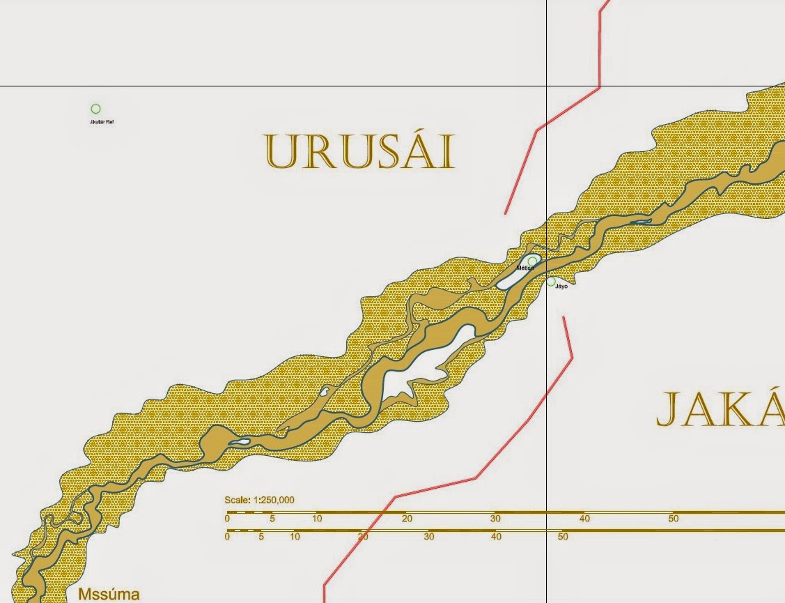
After a long break, I am starting to look at my "Digitizing Tékumel" project again. Here is another look at the Mssúma river along the border of Urusái and Jakásha provinces. The sákbe road runs south from Usenánu and crosses the river at what, in My Tékumel, I am calling the twin towns of Métlan and Jáyo. Métlan is in Urusái province, while smaller Jáyo is in Jakásha province. For inspiration I am drawing somewhat on the early history of Budapest which was originally two towns on opposite sides of the river.
To the west, Jikutlár fief is visible. This fief features in one of the Solo Gamebooks - the one with the green cover, IIRC. I have located it according to the description in the book: approximately 200 tsán north of Jakálla. The other named places - Anján Wood, Cholúga, Máshtla, Diridé, and Chorkúda - all come from that adventure.
The other two named features - Lake Vejápa and the Abásun River - are my additions. I've stolen the name "Vejápa" from a work of popular science fiction that many may recognize. The word "abásun" means "white" in Tsolyáni, so the Abásun River is the White River. I haven't decided why it is called that yet.
The Abásun River is a dry bed during the hottest months of the year but as the rains come and the Mssúma River rises it flows south into Lake Vejápa. The lake itself gets quite shallow in spots during the summer. Note the small island in the middle. It is possible to wade out to it some summers if one knows the route. When the floods come the Mssúma overflows its banks and the Abásun disappears as the whole area is inundated. Lake Vejápa expands about ten times its original size and neighbouring villages exist as tiny islands or clusters of huts on stilts.

Sunday, November 30, 2014

The Mssúma River - Digitizing Tékumel, Part 9


The Mssúma River Delta

Moving on from yesterday's post, here is the Mssúma river delta - still only roughly blocked in. You will notice that I have decided to show the Mssúma in a sandy-yellow rather than the blue normally used for water. It seemed fitting considering that is closer to the colour!

Shown is the "main channel" - keeping in mind that this is changeable over time. Also shown are some secondary channels, also changeable. These are channels that might go dry in the summer but are open for much of the rest of the year. The lighter toned areas represent an approximation of the flood plain. They are just blocked in at the moment and will no doubt be modified. What I did initially was just trace the outer edge of the river as drawn on the Swords and Glory map. When scaled that feature became quite wide. The problem is that is too consistent a width which is a problem especially the closer to the source you get. A more realistic floodplain would, IMO, be narrower closer to the source and have more wider expanses - the river would of course inundate any low-lying areas. I just have to add some more in to make it look less regular.

This drawing also shows the village of Nisuel (lower left), Chokuga village and Jikutlar fief (top). These feature in one of the solo Adventures on Tékumel books.


Another view, showing the shallow lakes I've added...

These lakes, at lower left, are those mentioned in my U Bien Bridge post a few days ago. That line just to the right of them is part of a polygon I drew to attempt to enclose the Mssúma River watershed, which in turn allowed me to estimate its area. The horizontal wavy line is the approximate boundary of the Flats of Tsechélnu. My assumption is that during flood season the river inundates large areas...

Also note that I've been making up names again: Urúra, a village or town near by those lakes.


Moving up river...

Where the sákbe road meets the river I have chosen to place two small towns; in my campaign they are called Métlan and Jáyo. They are meant to be the Tsolyáni equivalent of Buda and Pest. :-)

The outer edges of the so-called floodplain really need to be worked on. I have to add some minor rivers and streams. In the real world I think there would be hundreds of them! Note again the secondary channels that dry up during the hot summer. Note also that there are two that I have drawn distinct from each other. That is because I think they would become dry at different times, the shallower channel drying first.

By a coincidence I was watching BBC World News or Al Jazeera (I think - I suppose it might have been a North American station but I somehow doubt it) earlier this year and they were interviewing the peasant farmers in Pakistan displaced by the flooding. Apparently the government wants to permanently resettle these people but they don't want to leave, despite being routinely displaced. The reason they don't want to leave is that the flooding deposits so much rich sediment that the crops grow really well. Their whole lifestyle is built around temporary homes and the difference this year is just that the flooding was more extensive. 

I think the Mssúma river farmers would be much the same. Their main crops would be grown in the flood plain where the soil is rich. Their main clan houses would be near by the edge of the floodplain or on higher areas within it. If necessary they would build more temporary residences within the plain, possibly on stilts. When the floods come they would move to the main clan houses, and as the waters recede they would move back and plant their crops for the new growing season.


Mssúra

This map moves up river a bit, again showing the main and secondary channels and a roughly blocked in flood plain. Also shown is the village of Mssúra, another of my made up places. My assumption is that the Mssúma river valley is densely populated - perhaps the most densely populated area in Tsolyánu - so there should be lots of towns and villages all along its length. 


Usenánu


What's this? Two additional rivers?!!

Moving north again we come to the city/town/village of Usenánu. I have always thought of it as a city but in the Deeds of the Ever-Glorious it is referred to as a village. Of course, the scribe who wrote that passage might have been writing it at a time when Usenánu was indeed only a village!

The problem is that one expects to have everything set out in stone for the game. The Professor, however, presented his work as actual historical documents so there are bound to be contradictions, or seeming contradictions. Of course, this isn't actually a problem at all; by doing it this way each game master can tailor the world to suit his needs. And it adds an awesome amount of flavour! :-)

At Usenánu the "village/city" thing isn't the only seeming contradiction I encountered. To the best of my knowledge, descriptive references are few and far between. There is the above mentioned reference in the description of the legion raised there, but the only other reference I know about is the text description in the "Growing up on Tékumel" booklet. This is the little booklet that details character generation. In it the male character example is from Usenánu and he provides a short description of the place, giving some names for the main streets and plazas and that sort of thing.

He mentions the sákbe road heading off to the west but fails to mention that it crosses a river even though, based upon the location of the symbol on the map, it should cross the river coming south from Háuma. He does mention docks and - IIRC - a ferry to the east. And he names that river as the Umétla river whereas the Gardasiyal map calls it the Arjáshtra!

So the initial problem is are we referring to the same river with two different names? Not without real world precedence; the Ganges seems to have many names along its length. Or are there two rivers?

My solution is to assume the latter. I assume that the river that flows south from Háuma is the Arjáshtra river, but as it gets wider - and perhaps there are sometimes two channels that entwine about each other - the name Umétla comes into the picture. This name, occurring further south, is given to the wider channel whereas the narrower one retains the name Arjáshtra.  Just north of Usenánu the two diverge and the smaller Arjáshtra continues almost directly south while the wider Umétla flows more to the south-east. At this point the Arjáshtra channel is so insignificant that in the high summer it might completely dry up, so it is no wonder that it does not receive a mention.

On the map shown above I've used the Pála Jakálla city map as a sort of placeholder. I've only tried a rough pencil sketch of the place itself. I don't recall the population range given via the key on the Swords and Glory map. That is, I suppose the next step. I've tried to make the local topography interesting. I assume that the area with the Mssúma river label is prone to flooding which is why the sákbe road does that hook to the north. I also assume that there are ferries across both the Mssúma and Umétla rivers.

Monday, November 3, 2014

Métlan and Jáyo, in more detail...


Excerpt from digital mapping project and detail sketch.

Métlan and Jáyo


1)      The sákbe road running north to Usenánu. There is some question as to which side of the road the high side should be on. The road is fairly centrally located within the empire so facing a closest border becomes somewhat of a toss up. If the low side were closer to the river it might make river traffic more accessible. That is to say, loading things onto and off of the road. But then why not do that at one of the major centers on the river, and if coming from the hinterland why not cross under or through the road at some tower gate and load directly onto barges? Myself I think it more likely that there would be crossing points to allow this and river villages located at the popular spots to facilitate this traffic. A better argument is that if the high side faces east then it will provide more shade to travellers for a longer part of the morning thus easing their journey. For this reason I favour the high side of the road facing the river.
2)      The sákbe road head. Wherever travellers are able to join the road there must be long ramps to accommodate the chlén carts and litters. The slope of these ramps would probably be no steeper than the wheelchair ramps of today. The road head is where the road ends and ramps provide access to ground level. Typically there is a tower or fortress guarding access to the road beyond the ramps.
3)      Road Head village. A squalid village filled with cheap vendors and whores seeking to make money from the travellers. The clan houses of the ferrymen would be located here.
4)      Small local villages. These villages are generally poor and pretty squalid. The villagers fish and grow crops on the flood plain between the floods. The deposits of sediment laid down during the floods provides them with fertile soil and they get good yields but are poor none-the-less.
5)      The causeway. This is a very low stone causeway that runs from the edge of the typical high flood to the rivers edge. On the north side it runs right the way to the town gate, but on the south side it just runs across to the main river channel. The causeway mimics the structure of the sákbe road with three different levels but each level is only 2 inches (50mm) taller than the next lower level. This makes the causeway 6 inches (150mm) high at its tallest edge, which is that facing upstream. The width of the causeway is the same as the sákbe road. On the south side there are a year round ferries that cross the main river channel, but on the north side there are only ferries during the flood season.
6)      The Foreigner’s Quarter of Métlan is outside the town walls. There are small enclaves spread out over the south part of the island. There is a small Ahoggyá community near the southern tip. A few dilapidated huts surrounded by a low stockade. The few Ahoggyá who live here year round are mostly fishermen. A few also hire out to caravans or boats.
7)      The Páchi Léi enclave is in the wooded center of the island. It currently consists of a single member who has a good reputation as a doctor.
8)      There is a Swamp Folk enclave right at the rivers edge, on huts built up on stilts above the water. They work as fishermen and on the boats.
9)      The Shén enclave is perhaps the most numerous. They live in a series of huts at the end of the dockyards section of the town where most of them work as labourers. All are from the main Shényu egg-group and the police keep a watch full eye when other parties of Shén pass through, and also that they keep their distance from the Ahoggyá.
10)  The Pé Chói enclave is in the woods next to the Páchi Léi. They are few in number and generally are in imperial or temple service in the town. They avoid the river as much as possible.
11)  Another small human village, this one mostly home to clans involved in the docks, shipping or transport in general.
12)  The dockyards. Always busy with river traffic. Many caravans coming from districts to the east and west just transit by chlén cart as far as here and then switch to barges to travel up or down river at a faster rate.
13)  Near the town wall is that part of the Foreigner’s Quarter occupied by humans, and those few other races that don’t want to mingle with their own kind for whatever reason.
14)  Ferry routes across the main river channel. A number of competing clans run ferries across the river. These can range from large barges and boats to smaller craft that carry only a few persons at a time.
15)  Police and Naval docks. Home to the local River Police and occasional vessels of the Imperial Navy.
16)  Legion Fortress. A small fortress on the crag at the north end of the island. Has barracks than can accommodate several cohorts of troops but currently very sparsely garrisoned by the River Police and two imperial legions. The Legion of Mirkitáni, Hero of Victories, often has a contingent posted here, as does the Squadrons of Tlanéno the Steersman.
17)  The town of Métlan itself. A small walled Tsolyáni town on an island of the same name in the Mssúma river.  In some ways twinned with a smaller town of Jáyo on the south bank of the river opposite in much the same way that Buda and Pest in Hungary were formerly separate communities. Métlan is part of the province of Urusái. The town has a moderately sized temple to Avánthe and her cohort Dilinála and smaller temples to the other Gods of Stability, but only shrines devoted to the Lords and Ladies of Change.
18)  Temporary docks for Police and Naval vessels. The main Mssúma river channel often changes its course over time but has consistently kept the same bed were it flows by Métlan island. This means the island docks are of a more permanent construction than those on the south shore which have to shift position as the river floods. Not often used there is usually a sentry and there is a path that runners and patrols take to get to the town of Jáyo.
19)  Temporary public docks. Similar to the official docks on the east side of the causeway, these are designed to adjust to the height of the river. Dirt paths lead from the docks to the town proper.
20)  The Hirilákte Arena. Shared between the two towns of Métlan and Jáyo, it is not a proper arena at all, but rather is a circular array of stout posts driven into the riverbed and protruding a few feet above high water level. These delineate the area used for the events which are staged on a variety of barges and other boats as deemed appropriate. Spectators view the events from other boats or barges that are rowed over and anchored in place or tied up to the posts. There are also some platforms on tall stilts located at the typical low water mark on which are set up tents from which the arena referees and imperial representatives and their guests view the matches.  There is a considerable rivalry between the two towns and also between the temples of the two towns.  Many matches pit the two against each other, while other matches are “neutral” in nature.
21)   The Tower of Everlasting Regret – Imperial prison for the province of Jakásha. Along with the southern sákbe road, forms the main part of Jáyo’s defences.
22)   The sákbe road head. In this case the road runs into the base of the Tower of Everlasting Regret forming the eastern side of Jáyo’s town wall. The actual ramps that lead down into the town a placed just short of the road end. There is a gate that leads through the wall leading to a secondary road that heads east into the countryside.
23)  The southbound sákbe road that leads to Pála Jakálla or Jakálla itself. This road faces east providing morning shade for travellers.
24)  The town of Jáyo. Smaller than Métlan, it has few defences, relying upon the sákbe road for the most part. A low wall without any defensive towers covers the south, stretching from the road to the river bank. Similar to Métlan the so-called foreigner’s quarter is outside this southern wall. It is enclosed only by an earthen dyke which is largely overgrown with grasses and shrubs. Jáyo has large temples to Dlamélish and Hriháyal, smaller temples to the other deities of change and only shrines to the Gods of Stability and their cohorts.
25)   The North Channel fills first as the river begins to swell at the start of the flood season and stays longest when the riverbed begins to dry out. It is not very deep but small boats and flat-bottomed craft can be used on it. The Ahoggyá generally just wade across often going underwater for long stretches without any apparent concern.
26)  These dotted regions are those areas of riverbed that dry out during the dry season but are often under water during the floods. The actual extent of the flooding varies from year to year. As stated in (4) above, the soil is very fertile and provides good crops all along the river.
27)  These lines mark the approximate high flood mark of the river. The actual flood level varies from year to year and is often below this line but is also occasionally above the line as well. In such times the streets of Jáyo may be flooded, while Métlan stands high and dry on its outcrop in the middle of the river.
28)  The main course of the Mssúma river. The depth varies but deepest parts of the channel tend to be on the north and west sides nearest Métlan.

29)  This last non-human enclave is a small population of Pygmy Folk who have burrows in the hillside. The actual population is not known but as few are generally seen – or rather, few recognizable individuals are seen – it is thought to be low. The Tsolyáni have no knowledge of the extent of the burrow complex. 

Saturday, September 20, 2014

Digitizing Tékumel - Part 4: Detailing the Mssúma River


I've started to make a first attempt at detailing the Mssúma river. My personnal opinion is that, in character, it would be much like the Indus, Ganges and Brahmaputra rivers that flow through India, Pakistan and Bangladesh. I believe that the background material describes it as wide and slow moving, and filled with the yellow silt. We know that at least part of the region is subject to monsoon like rains so I am assuming that the rivers of the region are subject to floods and that their paths probably change over time as the river cuts a new path. 

If you examine the maps of the India, Pakistan and Bangladesh region that I linked to in my previous post you will see that the cartographers have noted that the rivers are subject to change. They also seem to indicate the typical "high water" boundaries of the rivers, though again that could potentially vary from year to year. My intent is to draw my version of the Mssúma river in the same manner.

A couple of things need to be decided upon. For example, width. I have traced the approximate centerline of the river as it appears on the Swords & Glory map. I did this as far north as Avánthar so far. I stopped because I had forgotten which branch was the Mssúma river. It seems that the right-hand branch is the river but I haven't gone back and added that bit. When I do I will be able to estimate the length of the river and compare it with real world examples.

The first thing I did was to offset the centerline on each side in one kilometer increments. This was so that I could get an idea of the river at various widths. I think I stopped at 5 kilometers total. You can see how it compares to the width of the line used to describe the river on the original map.

Then I used an AutoCAD tool called a spline to draw a curved line to represent a first attempt at each river bank. The intent is to add to this or modify as seems appropriate, adding or removing curves or changing the character so that it resembles the Indus river I showed in my last post. I am going to allow the original line to offer hints as to where islands and lakes might be located. Or perhaps allow it to indicate the extent of the river in a normal flood year.


This clip shown above shows the river in the region of Metlán and Jáyo, two small cities I invented. It just seemed to me likely that where the Sakbé road crossed the river there would be some sort of human habitation. I haven't done much to expand my initial descriptions of the cities but you can find my first stab at it here


This next picture shows Tsolyánu with a rectangular grid overlaid on it. Each grid rectangle is 200 kilometers by 150 kilometers and is sized so that it will fit on a typical B1 drawing sheet at 1:250,000 scale with plenty of room for a title block and key. I centered the grid around the immediate area about Jakálla and then expanded it from there. 


I'll also be adding the smaller tributary rivers and streams not shown on the larger map. Of course, I'll be making all that up as I'm pretty sure the Professor didn't provide any information that detailed. If you go back and look at that Mssúma river watershed picture from my last post you might notice that I have added distributary rivers at its mouth. My thinking is that as the river path has changed over time it is more likely to have run through the area of the Flats of Tsechélnu than it is the higher ground to the east of the river (in green on the map). I think it must resemble a situation somewhat similar (though on a smaller scale) to the Mouths of the Ganges. This can be found in detail on the maps I linked to last time.

Sunday, July 22, 2012

Some more thoughts about Metlán and Jáyo...


I've been doing a few doodles and researching the kind of names used for locations in existing cities. The names of Tsolyáni Emperors are popular for things like gates and major thoroughfares.

My thoughts on what the towns might look like are currently as follows:

They are focused primarily on commerce and travel. Clans related to transport - whether by porter or chlén cart; shipping; provisioning; wheelwrights; and entertainment of various kinds predominate. High clans might maintain small clan houses for their members to stay while travelling. Administrative buildings are small except those required for commerce and travel related needs. Temples restricted generally to small shrines as is the case in Sétnakh (see "Seal of the Imperium" Vol 1 No 1.)


Metlán - the larger of the two. More up-scale. River Police maintain a small barracks and wharf. Most of the nicer clan houses are located here. Hostels are more up-market as well. No permanent slave market. Small temple to Lady Avanthé. A number of clans run ferries across the river, competing with each other and with clans from Jáyo. The ferries are stratified like the hostels with most of the up-market ferries operated by clans based out of Metlán.


Jáyo - smaller and seedier than Metlán. Has a small but permanent slave market. Largely devoted to entertainments. The temples of Dlamélish and Hriháyel are well represented. Neither town has a proper "foreigner's quarter" but Jáyo itself is such a mix that it essentially serves this purpose. Generally speaking high status travelers prefer to travel through to Metlán rather than spend the night; unless, of course, they are given to hedonistic pursuits! The "House of the Emerald Curtain" caters strictly to those of high standing, with the House Guards roughly turning aside any who don't "make the grade."

Monday, July 16, 2012

Metlán and Jáyo


I've decided to start customizing My Tékumel a bit.

I've been reading up about the town of Sétnakh in the Seal of the Imperium (vol. 1, no. 1) and thinking about where else there might be town or perhaps even small cities. Looking at the maps I noticed how the Sákbe road running north from Jakálla crosses the Mssúma River on its way to Usenánu. It seemed likely to me that there would be a community there, probably on both sides of the river, as the Mssúma is too wide to bridge so there would have to be ferries. I decided I wanted something along the lines of Buda and Pest, two small towns that eventually grew to become modern-day Budapest.

For My Tékumel I decided on Metlán and Jáyo to be my version of Buda and Pest. Looking at the Provincial Map of Tsolyánu I noticed that they would be in two separate provinces: Urusái and Jakásha respectively. Perfect - I thought! All the more reason for them to be separate entities, and it means they can each have their own "City of the Dead" and municipal buildings, and the like. 


I think they are probably rivals to a certain extent. Perhaps there are cross river feuds? I picture Metlán as being the larger of the two with a strong leaning toward Avánthe. Jáyo, I see as being still feeling the influence of Jakálla and so Dlamélish has more of a presence there.


That's about all I've got for them as of yet, but while making the map I noticed a spot on the Swords and Glory map that I thought was just the right place for another town: Mssúra. And then I started wondering about why that unfinished Sákbe road running south from Haumá curved about so much. I decided there are probably some large lakes in the area and added those: The Chegá Lakes. Then I added another small town - Urúk - just for good measure.


I spent a bit of time thinking about the names Metlán and Jáyo but the others I came up with on the fly as I was making the map. No point in getting too hung up on the names! I'm not a linguist and cannot hope to get them in proper Tsolyáni form. Mssúra is of course inspired by the Mssúma River and Urúk is borrowed from Tolkien but at least looks similar in form to Urusái Province.


What I want to do is continue to expand these towns and use the area as the starting point at least for my games.