Showing posts with label Mssúma river. Show all posts

Monday, January 14, 2019

Digitizing Tékumel, part 24: The Mssúma Delta


The Mssúma Delta

Latest work: I've taken my earlier attempt at sketching the delta and added my latest efforts at Nisuél. If you enlarge the image you might be able to get the hint that the splash of colour at Nisuél is in fact the cover image that I am tracing.

My older rivers are much wider than that in the cover painting. At least, as I currently have that scaled. Nisuél is about 600 meters from north to south along the river, measuring between the wall bastions. So the Nisuél map symbol shown above is about a kilometer across.

My initial canals now have to be re-thought out and re-drawn. And I need to decide how many other larger clan holdings are in the delta - and which clans they are!

The Red Marshes I've blogged about before >>> Here. I have to decide how large to make them...and how many forested areas to add as hunting reserves.

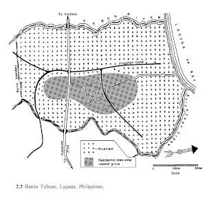
I also need to re-read the "Anatomy of a Peasant Economy" (LINK) to give me a better idea if I've scaled my Nisuél correctly. I can compare the real world example with the density shown in the artist's impression.

Edit: I just found a YouTube video from 2015 of  "Pila Laguna - Tansa and Tubuan".


Lots of footage of rice paddies and raised secondary roads; just ignore all the modern elements.


Barrio Tubuan, circa 1978

Saturday, December 22, 2018

Nisuél, Seat of the Clan of the Golden Sunburst - Part 2


Gylph of the Clan of the Golden Sunburst
(Artist unknown)


Nisuél

Original Source: 
Thonburi 1767-1782
Artist: Suthichai Ritthapatichai
Muang Boran Journal
Vol. 43 No. 4 October-December 2017

Plodding ahead with detailing the Mssúma river delta, starting with Nisuél, seat of the Clan of the Golden Sunburst, I have started to identify some of the location names. Don't forget to use the tags to find the rest of this series, and the overall "Exploring Tsolyánu" series.

Ever since I happened across this artist's impression of the city of Thonburi (Thailand) by Suthichai Ritthapatichai I have become more and more convinced that this is what the Mssúma delta looks like. Thonburi is even described as being a "canal and garden (or park) district". Which matches pretty much with Professor Barker's description of the delta being "...the Produce-Garden that feeds Jakálla..." and how it is "criss-crossed with canals and secondary roads." 

Nisuél amounts to a good-sized village. It is located on the Dhu’ónin River (Golden River), one of the many distributary rivers that thread to-and-fro across the Mssúma river delta. Between them are networks of major and minor canals, creating a patchwork of fields and ponds, with woodlots scattered here and there, and secondary roads weaving throughout it all as best they can. The population of the delta is pretty dense, mostly employed in agricultural practices. It is a pretty safe district, with Tékumel's more dangerous denizens kept far away by vigilant warders and a millennia old policy of extermination for any that stray too near.

I've done a bit of research on the Clan of the Golden Sunburst. I've looked up personages in the various sources, principal of which is always the "Hardison Guide", as I call it. One thing that bothered me was that Alva lists the Clan Patriarch as being named "Nisuél"; bothered me until today, that is, when it finally dawned on me that they were just following the long standing practice used by the legions of the Kérdu taking the name of the traditional Kérdu. i.e. "Sérqu" is passed down through the ages, from one general to the next. Indeed, the Hardison Guide mentions that the "17th Sérqu" was a member of the clan. So I am reconciled with the idea that the Clan Patriarch is called "Nisuél" even as it is used for the community itself.  

If you click on the above image you'll see I've used this in my attempt at naming the features on the painting. 

Nisuél's Manse - which is the principal residence of the sitting Clan Patriarch. 

Also shown is the Bastion of Sérqu, "Swath of Red", a reference to that 17th Sérqu mentioned in the Hardison Guide. A similar defensive work is at the southern end: the Tower of Kokún Vriyón, named after an Éngsvanyáli "Hero of the Age". 

Other features I've tentatively - this is still only a first draft - identified are:

The Channel-Master's Station and the Canal-Master's Lodge, two of the clan officials charged with the smooth running of the Clan's business. I suspect the Channel Master out-ranks the Canal Master. 

The Palace of Serene Repose, a guest-house for noble visitors.

The Domicile of Iron, one of the clan's own Temple and/or Mausoleums.

The Mansions of Resplendent Glory, the main clanhouse complex. 

The Halls of the Exhalted, more Temples and Mausoleums, including monuments dedicated to the Clan's greatest ancestors.

The Guild of Iron, one of the subservient clans I've identified, this being hereditary warriors and bodyguards. I don't think "Guild of Iron" has been used before, and while there are no guilds as such, the term guild has been used: the Temple of Qon's "Guild of those Who Repel the Dark" (Source: Mitlanyál, Vol. 1).

The Barracks of the Guild of Iron, barracks for the Household Guards, almost all members of the Guild of Iron clan.

The Palace of Heroes, being more palaces and monuments to the Clan's glorious past. Note that I think clan apartments would be scattered among these complexes for senior members of the clan to reside in. 

So that is my start. As I said, a first draft. Coming up with extravagant sounding names ain't easy you know! ;-)

Saturday, August 4, 2018

Nisuél, Seat of the Clan of the Golden Sunburst - Part 1


Thonburi 1767-1782
Artist: Suthichai Ritthapatichai
Muang Boran Journal
Vol. 43 No. 4 October-December 2017

I discovered this image on the Patreon page of one Munkao: 


I'm not sure how active he is anymore, but even if you do not subscribe you should take a moment or two (or three!) to browse his public posts. There is a lot of useful stuff there!

My first thought on seeing this image was: "Wow, that is what the Mssúma river delta must look like! And that is the village of Nisuél!" 

This is an area I have been trying to draw as part of my Digitizing Tekumel project.  I know it to be the seat of the Clan of the Golden Sunburst from the third solo game-book: "Beneath the Lands of Tsolyánu". (The one with the green cover.)


These books are Excellent!
Highly Recommended!


Nisuél 

Headquarters of the Clan of the Golden Sunburst

Located about 100 tsán north of Jakálla in the heart of the Mssúma river delta.

The village contains more clan houses than just those belonging to the Golden Sunburst; there would be subsidiary clans, hereditary vassal clans, perhaps a bodyguard clan, or a boating clan, and similar. Looking at the painting, I would declare that the large white buildings were Golden Sunburst clan houses. The other large buildings are those of subsidiary, or vassal clans closely tied to their senior clan. The lesser buildings are perhaps still other clans who are not tied to the Clan of the Golden Sunburst but whose clan business requires their presence. And of course there are workshops, storage buildings and the like as well. The buildings near the fields are not clan houses of course but are workshops or storage areas, or are intended to provide shelter to "Field Watchers" in the outlying areas.

The large river is one of the distributary rivers branching off the Mssúma river as it reaches the delta. There are dozens such rivers of varying size. Nisuél is on the Dhu’ónin River, the Golden River. 

Other river names I've come up with are:

Festival River Gohóimu River
Fever River Ubó River
Fear River Ssünrü River
Mad River Ssánga River
Eternal River Prazhúrin River
Red River Kárin River
Black River Mikárun River
Emerald River Jangáivu River
Green River Zháurun River
Grey River Tathén River
Wild River Baradá River
White River Abásun River
Exalted Emperor River Kólumeljarài River
Ever-glorious Empire River Kólumelbabàrkohàya River
False River Ogrún River
Golden river Dhu’ónin River
Ghost River Ssudú River
Forbidden River Tabár River
Gods Protect Us Sharé River

Some of these, such as the Sharé, Ssünrü, Ssánga and Ubó Rivers, I intend to use in the Flats. 


My existing sketch of the delta


I shall have to re-draw my delta to match the river shown in this painting!

As the solo game-book text states, the delta is 

"...lush and green. It is crisscrossed by canals and secondary roads, for this is the produce-garden that feeds Jakálla and its suburbs, Músa Jakálla and Pála Jakálla. The great clans that own these lands are old, wealthy, and - to be honest - stodgy. The peasants you meet bow humbly as your litters pass; the slaves tramp in endless columns off to the fields in the morning and back again at night; the Chlén-carts are laden with vegetables and fruits and grain; the tax collectors appear, obscenely sleek and well-fed. This is the Empire as it has been for almost two thousand years..."


The Clan of the Golden Sunburst
Primary Lineages:
hiQolyélmu
hiTétkolel

Clan-Patriarch: Lord xxx hiQolyélmu

Other Notables:
Clan-Elder Srikandómo hiTétkolel
Lord Dalkén hiQolyélmu, a son of the clan-patriarch.
Jórudu hiTétkolel, a distant cousin of Lord Dalkén hiQolyélmu. 


That's all for now!

I'll post more in part 2.

Sunday, August 9, 2015

Digitizing Tékumel, Part 21: More on Appendix '0'...


The above map shows which pages of the report cover which sections of river, including those referenced in my last post.

It is important to remember the differences between the Mssúma and the Nile while trying to decide if there are any similarities. For one, the Mssúma river does not flow through a desert. There is a hot season, to be sure, but the landscape around the river seems to be more like plains with high levels of cultivation. It would have forests - possibly extensive forests - in parts.

If I had a useful description of the Ganges or the Amazon or even the Mississippi - before the US Corps of Engineers did their thing - I would look at that as well. This happens to be the most detailed report on the passage of a large river, and the obstacles faced, that I know about.


The map below shows the areas referenced in the pages immediately above. There is an extra cataract (marked "Upper Gate?") - I'm not sure if it is the gate described in the text or whether it was somehow left out of the report. The distances listed don't seem to fit...


Friday, August 7, 2015

The Sudan Campaign 1884-1885


I was lucky enough to get my hands on a copy of the reprinted Official Report on the Sudan Campaign 1884-1885, ie. the Relief of Gordon. Its quite an interesting read, even though it is largely about logistics. The whole thing seems to have been a logistical nightmare!

For example, after they decided to use whalers to transport the troops up the river it was found that to obtain a large enough number they had to commission them from many different boat builders. The boats were built to the same general specifications and came with masts, oars, sails and rigging, rudders, awnings and various spare parts.

When they arrived in Egypt there was a contractor ready to transport the boats from the transport ships to the railhead. Here they encountered a snag as the contractor declared that his contract was only to move the boats themselves, and not all their accoutrements. Eventually all these bits were put in storage and the boats were moved by themselves.

When the contract was finally amended to include the accessories it was found firstly that some of the equipment had "gone missing", and secondly that the equipment supplied by each manufacturer was designed to fit their boats and not any others! 

A fine pickle one might say!

There were other issues such as the loading platforms at the railhead having to be rebuilt to allow for proper and efficient loading of the trains. The problems just go on and on. Never mind the Mahdi!

My interest at this time is pertaining to the nature of the river before it was altered by dams and other engineering. There are so few unaltered rivers left in the World! I have heard that there is one left in Siberia that has no man-made additions. This account has detailed descriptions of the river and the obstacles presented by the cataracts. First there is Appendix 0 which is a report on the 1st through 3rd cataracts that was prepared as the expedition was being planned. There are also accounts of the trip up the river and back down.

My ultimate goal is to use this information as inspiration for what the Mssúma river might look like in the Tekumel campaign. And if I eventually do any Sudan gaming on the side that is just gravy! :-)

Some of the maps included with the book...


Appendix 0 - pages 141 to 157


Tuesday, July 21, 2015

Digitizing Tékumel, Part 19: a return to the Mssúma river valley...


After a long break, I am starting to look at my "Digitizing Tékumel" project again. Here is another look at the Mssúma river along the border of Urusái and Jakásha provinces. The sákbe road runs south from Usenánu and crosses the river at what, in My Tékumel, I am calling the twin towns of Métlan and Jáyo. Métlan is in Urusái province, while smaller Jáyo is in Jakásha province. For inspiration I am drawing somewhat on the early history of Budapest which was originally two towns on opposite sides of the river.
To the west, Jikutlár fief is visible. This fief features in one of the Solo Gamebooks - the one with the green cover, IIRC. I have located it according to the description in the book: approximately 200 tsán north of Jakálla. The other named places - Anján Wood, Cholúga, Máshtla, Diridé, and Chorkúda - all come from that adventure.
The other two named features - Lake Vejápa and the Abásun River - are my additions. I've stolen the name "Vejápa" from a work of popular science fiction that many may recognize. The word "abásun" means "white" in Tsolyáni, so the Abásun River is the White River. I haven't decided why it is called that yet.
The Abásun River is a dry bed during the hottest months of the year but as the rains come and the Mssúma River rises it flows south into Lake Vejápa. The lake itself gets quite shallow in spots during the summer. Note the small island in the middle. It is possible to wade out to it some summers if one knows the route. When the floods come the Mssúma overflows its banks and the Abásun disappears as the whole area is inundated. Lake Vejápa expands about ten times its original size and neighbouring villages exist as tiny islands or clusters of huts on stilts.

Saturday, December 27, 2014

The Kárinjàjzayal, or the "Red Marshes"


The Kárinjàjzayal

These marshes in the Mssúma river delta are home to a species of red grasses and are what give the Kárin river it's name. The word "kárin" meaning "red" in Tsolyáni.


Spring and Summer


Autumn and Winter

Friday, December 19, 2014

The Canals of Nisuél, Digitizing Tékumel, Part 16


The Mssúma Delta

The green-covered solo game book, "Adventures on Tékumel, Part 2, Volume 3: Beneath the Lands of Tsolyánu" provides the only published description of Nisuél and the surrounding region. The village of Nisuél is the headquarters of the Clan of the Golden Sunburst, a high status clan with a long and illustrious history. It is stated to be about 100 tsán north of Jakálla and in the Mssúma river delta. The delta is described as "lush and green" and "crisscrossed by canals and secondary roads". It is said to be the "produce-garden" that feeds the cities to the south. 

Here I've started drawing in some canals. The book suggests that there are multiple fiefs in the area so that probably means more villages and more canals. To be honest I hadn't pictured it as this developed, but I could be thinking of the part of the delta further south and west. I think I'm going to limit the densely cultivated area to the area to the east of the Nyélmeyal river.

To give a sense of scale I've drawn two circles, both centered on Nisuél. The smaller has a 10 km radius and the larger a 50 km  radius. 


The Southern Coast

Next up is to sort out where my rivers (see list of names on the map and in my last post) are going to go. The intent is fill in the area between Penóm and Point Kuné with them. Maybe there could be one to the east of the Nyélmeyal river as well. We'll see...

Friday, December 12, 2014

The Nyélmeyal - the River of Dreams - Digitizing Tékumel, Part 14


The Nyélmeyal River

Today's post follows closely on from yesterday and my supposition that the Mssúma River has not always flowed into the Gulf of Perudáya. Assuming that this was indeed the case and that the First Imperium city of Ngála was located on the banks of the river - both highly speculative (but fun) assumptions - what would the river have looked like? Or, more importantly, what does it look like during our current epoch?

The above drawing shows part of my initial attempts. I have even come up with a name - the Nyélmeyal - which I'm fairly certain hasn't been used before. The word "Nyélmeyal" translates as "dreams", making it the "River of Dreams". As it now flows languidly by the ruins of ancient Ngála through the jungles and swamps of what I take to be one of the wilder parts of the Tsechélnu Flats I think the name is fitting. 

Nowadays the ruins are mainly used for demon-related rituals of the temple of Hriháyal. I think the best route for the priestesses would be to take a ferry over to Ngálar Déka from Jakálla and then follow the sákbe road north until it crosses the Nyélmeyal river. At that point I assume there would be a temple and a landing with boats to convey the groups down river to Ngála. Far better than trekking overland through the swamps!

I had a bit of difficulty doing screenshots because the orientation of the area doesn't fit the landscape monitor I use. At least, not at the zoom level I wanted.

So here are two PDF files...


Please let me know if you have any issues with these files. 

Nisuél is stated to be the headquarters or seat of the Clan of the Golden Sunburst, which rose to prominence during the Empire of Éngsvan hla Gánga, that of the Priest-Kings, long before the current empire existed. The area around the village is stated in the green solo book to be "crisscrossed with canals and secondary roads" all of which have yet to be drawn in. My speculation is that in ages past the Mssúma river flowed past Nisuél and joined with what is now called the Nyélmeyal river to reach the sea to the west of Point Kuné. What caused it to change course - assuming you accept this supposition - is unknown, but it might possibly be assumed to have occurred as a result of the cataclysm that sank part of the island of Gánga, drowning the capital of the Priest-Kings empire. 

Thursday, December 11, 2014

Ngála - Digitizing Tékumel, Part 13


The ruined city of Ngála originally dates from the First Imperium, which flourished some fifteen millennium  prior to the current time. It is located in what is now the Tsechélnu Flats. Did the flats exist back then? That is three thousand years before Éngsvan hla Gánga and almost thirteen millennium before the cataclysm that ended that Empire. Personally I think that the flats are a byproduct of that seismic event. I'm not sure if this is stated anywhere though.

The reason I bring this up is because it occurred to me today that the Mssúma River might not have always flowed into the Gulf of Perudáya. I know that the Indus river changed its path as the result of an earthquake. Why not the Mssúma River?

It seems reasonable to me that if Ngála is one of Queen Nayári's, "gleaming cities of the South" it is highly likely it would be built on a major watercourse. My speculation is that instead of curving east and then flowing into the gulf, the river instead flowed south west to Ngála and then south to enter the ocean to the west of Point Kuné in hex 2713.


I'm going to do some sketching tomorrow. I have the start of it blocked in, I think, as I rather fancy that Nisuél - seat of the Golden Sunburst Clan IIRC - also has a similar ancient heritage. This is from a period that pre-dates the sákbe roads if I'm not mistaken. 

I need to look at the Indus river for inspiration as to what happens to the old riverbed, only in that example the region is much drier and so might not be entirely appropriate...

Wednesday, December 3, 2014

Digitizing Tékumel, Part 11 - a first look at Lake Vejápa


Lake Vejápa

Here is that large lake that I showed off yesterday. I've given it a name, stolen from I don't know where. OK, I know where...do you? ;-)

The idea is that the lake is around all year but varies considerably in size. When the rains start the channels flowing from the Mssúma river fill and it starts to grow in size. Then the floods come - some years higher than others - and the lake overflows its banks until some or all of the shaded area is inundated. In many areas the water will not be that deep: waist deep and often less than that, but in the central portion the waters could be many meters deep. The white areas are those areas that generally do not get flooded though when those once-in-a-hundred-year rains come, even those areas may see some flooding.

This area will have small villages or clusters of clan houses dotted all across the floodplain. They will typically be up on mounds above the normal flood level, or will be on the shores where it rarely floods. When the water recedes they plant their crops and reap the benefit of the rich soil the rivers sediment provides.

What is on that island in the center of the lake? A monastery? A shrine? Or perhaps that is where the local fief-holder has his seat? Which makes me wonder again about fiefs? How big should they be?

Tuesday, December 2, 2014

Expanding the Mssúma River Floodplain - Digitizing Tékumel, Part 10


I've tried to line these up so you can see how the river is shaping up in one go. Not sure how it will display in different browsers...

Here I've started expanding the Mssúma river floodplain. It was bothering me that it was so uniform and narrow. I don't think it would be in a real world. So I pushed it back in a few spots, and added areas where the elevation is high enough that they end up as islands when the river is in full flood. Not that they are necessarily "hills" as such, just enough of a rise to avoid the flooding. Of course, this would vary from year to year. I remember reading a bit about the Sikh wars and I seem to recall all the towns and villages being up on mounds or hilltops.

In the bottom picture I've added another lake. This lake is there all year round but during the floods it expands to over 5 or 6 times its size! I've actually gone a bit further than this, sketching in islands and ox-bow lakes as well as secondary channels. I've also started penciling in some lesser tributaries. Hopefully I'll be able to show you these in a day or two.

Part of my reason for adding the lake is to give a reason for the sákbe road to curve to the west like it does. Why wouldn't it go as straight as possible across the river bend? And there are not enough lakes shown on the large maps anyway. What are there - three, maybe four, in the whole map set?

I've also started to think about how fiefs might be distributed in this new terrain, and who owns what. Well, we know the Emperor "owns" everything, but who are the fief-holders. These will include the temples as well as the clans and nobles. I'll have to look up where each province is administered from as well.