The Mssúma Delta
Latest work: I've taken my earlier attempt at sketching the delta and added my latest efforts at Nisuél. If you enlarge the image you might be able to get the hint that the splash of colour at Nisuél is in fact the cover image that I am tracing.
My older rivers are much wider than that in the cover painting. At least, as I currently have that scaled. Nisuél is about 600 meters from north to south along the river, measuring between the wall bastions. So the Nisuél map symbol shown above is about a kilometer across.
My initial canals now have to be re-thought out and re-drawn. And I need to decide how many other larger clan holdings are in the delta - and which clans they are!
The Red Marshes I've blogged about before >>> Here. I have to decide how large to make them...and how many forested areas to add as hunting reserves.
I also need to re-read the "Anatomy of a Peasant Economy" (LINK) to give me a better idea if I've scaled my Nisuél correctly. I can compare the real world example with the density shown in the artist's impression.
Edit: I just found a YouTube video from 2015 of "Pila Laguna - Tansa and Tubuan".
Lots of footage of rice paddies and raised secondary roads; just ignore all the modern elements.
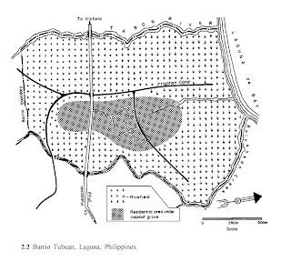
Barrio Tubuan, circa 1978


I'm glad to see you are still working on this!
ReplyDeleteYou aren't going to make the river channels narrower though, are you?
Not the main river channels. I remembered that Nisuel isn't a port, but just the clan house of a prominent clan. So those vessels need not be expected to be large shipping craft; in fact, there are as likely to be carrying personages as goods, and the goods they carry are more likely to be luxury items or artifacts than bulk goods.
ReplyDeleteWhat I've done is delete those canals as drawn on my old draft. I've started sketching with pencil and paper outwards from Nisuel. To get inspiration I went and Googled Tubuan Barrio, Philipines and had a look in GoogleMaps, satelite view. And then I used Street view to take looks over the lake and the fields. Then I went and looked in other locals. It seems like a typical sized rice paddy might be 25 meters by 50 (or 50 x 100 - can't recall off the top of my head).
In 1978 (per that research paper I reference) Tubuan had 95 households: 54 farmers with land and 41 landless workers. Translating to a Tekumel context I think these would still be part of the same clan, just representing lineages of different status. In the case of Nisuel and environs, not Golden Sunburst, but another of it's client clans or another large [allied] clan that specializes in agricultural pursuits. So there would be a clanhouse around somewhere for that clan as well!
And I am reminded about how even the Tlakotani clan has lineages of peasant farmers...
I'm glad, I really like the "big delta" thing you have going on, it would be a shame to downsize it.
ReplyDeleteSpeaking of big deltas, have you thought about looking to other big deltas for your analogues re villages and farmland? Like maybe the Mekong or Meghna?
The Mekong and especially the Tonle Sap is a very interesting area. There is so much water in the rainy season it fills up and the Tonle Sap expands 10x or more!
ReplyDeleteCurrently in the Chakas investigating the Ito Clan and the Kachor Tribes. :-)
ReplyDelete