Tuesday, December 2, 2014

Expanding the Mssúma River Floodplain - Digitizing Tékumel, Part 10


I've tried to line these up so you can see how the river is shaping up in one go. Not sure how it will display in different browsers...

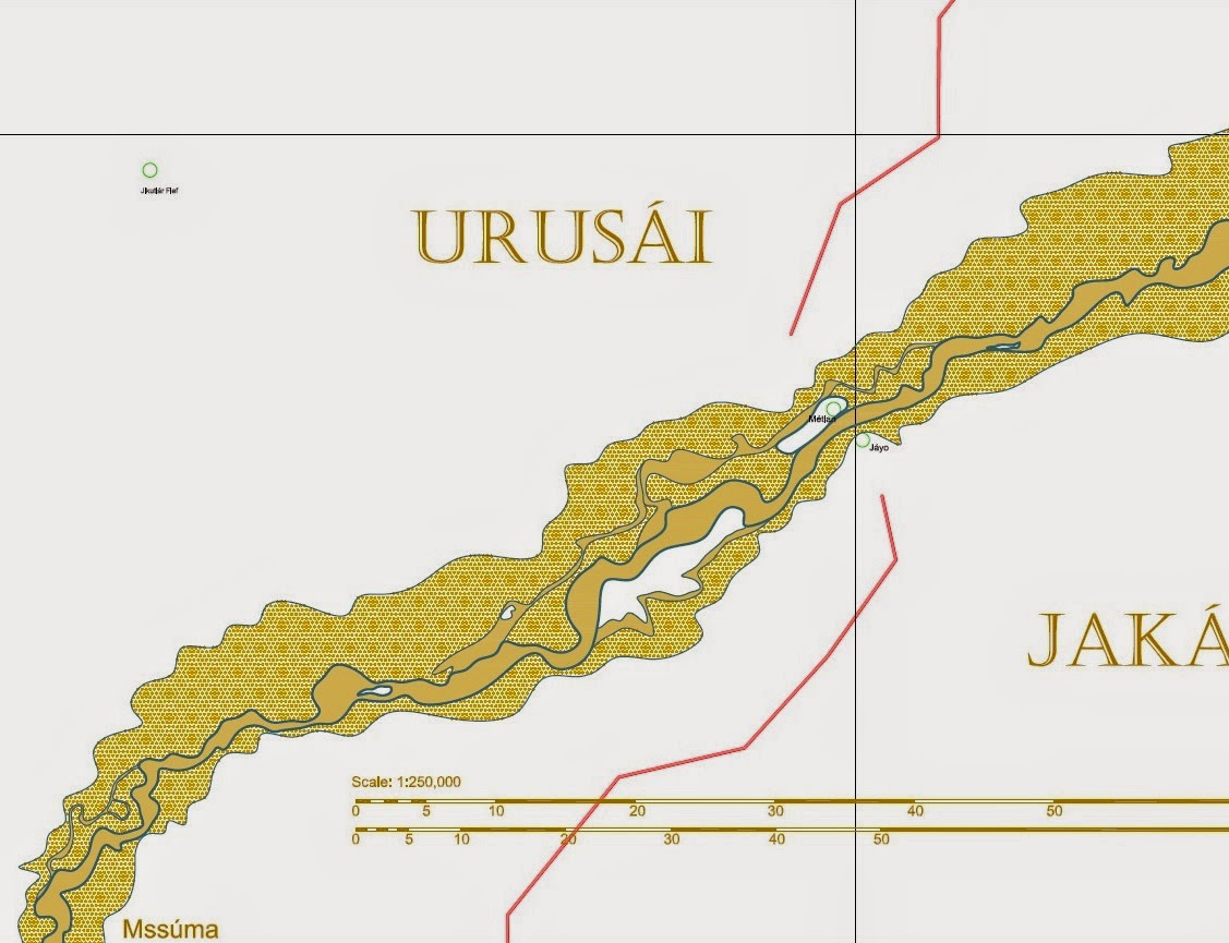
Here I've started expanding the Mssúma river floodplain. It was bothering me that it was so uniform and narrow. I don't think it would be in a real world. So I pushed it back in a few spots, and added areas where the elevation is high enough that they end up as islands when the river is in full flood. Not that they are necessarily "hills" as such, just enough of a rise to avoid the flooding. Of course, this would vary from year to year. I remember reading a bit about the Sikh wars and I seem to recall all the towns and villages being up on mounds or hilltops.

In the bottom picture I've added another lake. This lake is there all year round but during the floods it expands to over 5 or 6 times its size! I've actually gone a bit further than this, sketching in islands and ox-bow lakes as well as secondary channels. I've also started penciling in some lesser tributaries. Hopefully I'll be able to show you these in a day or two.

Part of my reason for adding the lake is to give a reason for the sákbe road to curve to the west like it does. Why wouldn't it go as straight as possible across the river bend? And there are not enough lakes shown on the large maps anyway. What are there - three, maybe four, in the whole map set?

I've also started to think about how fiefs might be distributed in this new terrain, and who owns what. Well, we know the Emperor "owns" everything, but who are the fief-holders. These will include the temples as well as the clans and nobles. I'll have to look up where each province is administered from as well.

Sunday, November 30, 2014

The Mssúma River - Digitizing Tékumel, Part 9


The Mssúma River Delta

Moving on from yesterday's post, here is the Mssúma river delta - still only roughly blocked in. You will notice that I have decided to show the Mssúma in a sandy-yellow rather than the blue normally used for water. It seemed fitting considering that is closer to the colour!

Shown is the "main channel" - keeping in mind that this is changeable over time. Also shown are some secondary channels, also changeable. These are channels that might go dry in the summer but are open for much of the rest of the year. The lighter toned areas represent an approximation of the flood plain. They are just blocked in at the moment and will no doubt be modified. What I did initially was just trace the outer edge of the river as drawn on the Swords and Glory map. When scaled that feature became quite wide. The problem is that is too consistent a width which is a problem especially the closer to the source you get. A more realistic floodplain would, IMO, be narrower closer to the source and have more wider expanses - the river would of course inundate any low-lying areas. I just have to add some more in to make it look less regular.

This drawing also shows the village of Nisuel (lower left), Chokuga village and Jikutlar fief (top). These feature in one of the solo Adventures on Tékumel books.


Another view, showing the shallow lakes I've added...

These lakes, at lower left, are those mentioned in my U Bien Bridge post a few days ago. That line just to the right of them is part of a polygon I drew to attempt to enclose the Mssúma River watershed, which in turn allowed me to estimate its area. The horizontal wavy line is the approximate boundary of the Flats of Tsechélnu. My assumption is that during flood season the river inundates large areas...

Also note that I've been making up names again: Urúra, a village or town near by those lakes.


Moving up river...

Where the sákbe road meets the river I have chosen to place two small towns; in my campaign they are called Métlan and Jáyo. They are meant to be the Tsolyáni equivalent of Buda and Pest. :-)

The outer edges of the so-called floodplain really need to be worked on. I have to add some minor rivers and streams. In the real world I think there would be hundreds of them! Note again the secondary channels that dry up during the hot summer. Note also that there are two that I have drawn distinct from each other. That is because I think they would become dry at different times, the shallower channel drying first.

By a coincidence I was watching BBC World News or Al Jazeera (I think - I suppose it might have been a North American station but I somehow doubt it) earlier this year and they were interviewing the peasant farmers in Pakistan displaced by the flooding. Apparently the government wants to permanently resettle these people but they don't want to leave, despite being routinely displaced. The reason they don't want to leave is that the flooding deposits so much rich sediment that the crops grow really well. Their whole lifestyle is built around temporary homes and the difference this year is just that the flooding was more extensive. 

I think the Mssúma river farmers would be much the same. Their main crops would be grown in the flood plain where the soil is rich. Their main clan houses would be near by the edge of the floodplain or on higher areas within it. If necessary they would build more temporary residences within the plain, possibly on stilts. When the floods come they would move to the main clan houses, and as the waters recede they would move back and plant their crops for the new growing season.


Mssúra

This map moves up river a bit, again showing the main and secondary channels and a roughly blocked in flood plain. Also shown is the village of Mssúra, another of my made up places. My assumption is that the Mssúma river valley is densely populated - perhaps the most densely populated area in Tsolyánu - so there should be lots of towns and villages all along its length. 


Usenánu


What's this? Two additional rivers?!!

Moving north again we come to the city/town/village of Usenánu. I have always thought of it as a city but in the Deeds of the Ever-Glorious it is referred to as a village. Of course, the scribe who wrote that passage might have been writing it at a time when Usenánu was indeed only a village!

The problem is that one expects to have everything set out in stone for the game. The Professor, however, presented his work as actual historical documents so there are bound to be contradictions, or seeming contradictions. Of course, this isn't actually a problem at all; by doing it this way each game master can tailor the world to suit his needs. And it adds an awesome amount of flavour! :-)

At Usenánu the "village/city" thing isn't the only seeming contradiction I encountered. To the best of my knowledge, descriptive references are few and far between. There is the above mentioned reference in the description of the legion raised there, but the only other reference I know about is the text description in the "Growing up on Tékumel" booklet. This is the little booklet that details character generation. In it the male character example is from Usenánu and he provides a short description of the place, giving some names for the main streets and plazas and that sort of thing.

He mentions the sákbe road heading off to the west but fails to mention that it crosses a river even though, based upon the location of the symbol on the map, it should cross the river coming south from Háuma. He does mention docks and - IIRC - a ferry to the east. And he names that river as the Umétla river whereas the Gardasiyal map calls it the Arjáshtra!

So the initial problem is are we referring to the same river with two different names? Not without real world precedence; the Ganges seems to have many names along its length. Or are there two rivers?

My solution is to assume the latter. I assume that the river that flows south from Háuma is the Arjáshtra river, but as it gets wider - and perhaps there are sometimes two channels that entwine about each other - the name Umétla comes into the picture. This name, occurring further south, is given to the wider channel whereas the narrower one retains the name Arjáshtra.  Just north of Usenánu the two diverge and the smaller Arjáshtra continues almost directly south while the wider Umétla flows more to the south-east. At this point the Arjáshtra channel is so insignificant that in the high summer it might completely dry up, so it is no wonder that it does not receive a mention.

On the map shown above I've used the Pála Jakálla city map as a sort of placeholder. I've only tried a rough pencil sketch of the place itself. I don't recall the population range given via the key on the Swords and Glory map. That is, I suppose the next step. I've tried to make the local topography interesting. I assume that the area with the Mssúma river label is prone to flooding which is why the sákbe road does that hook to the north. I also assume that there are ferries across both the Mssúma and Umétla rivers.

Saturday, November 29, 2014

The Gulf of Perudáya


The Gulf of Perudáya (in part)

Here is a close up of the Gulf of Perudáya in the immediate vicinity of Jakálla. I haven't done anything with the sandbanks beyond my initial sketches. I have added a couple of named places. It seems obvious that there must be a village or town at the the end of the sákbe road that is shown to the left in the above picture, and ferry service that runs from it across to Jakálla and back. I have named it "Ngálar Déka"; "Ngálar" is the name of the province on that side of the gulf and "déka" means boat in Tsolyáni, so it is "Ngálar Boat" (or ferry). 

I have also assumed a ferry near the mouth of the Ranánga river which services the secondary road out of Pála Jakálla. I am utilizing a borrowed map of Pála Jakálla and this map has an eastern gate called the "Thráya Gate", presumably because the road leads to Thráya. So that leads me to assume a ferry to get travelers across the Ranánga in order to reach the sákbe road that runs east along roughly the same line as the river. I have decided that this is an old route and so come up with "Pála Dékakh", or "Yesterday's Boat" in Tsolyáni. 

There is a sákbe road that crosses the Ranánga a little further up river. My assumption is that this ferry has been around longer than that one. Note that in both cases we are talking long periods of time, given the age of the Tsolyáni Empire. Also note that the route east of the Thráya Gate, across the ferry and hence onto the eastbound sákbe road is much quicker than following the road north out of Pála Jakálla and around. A canny merchant would know this while a stuffy noble might take the longer route (not that he would be walking!)

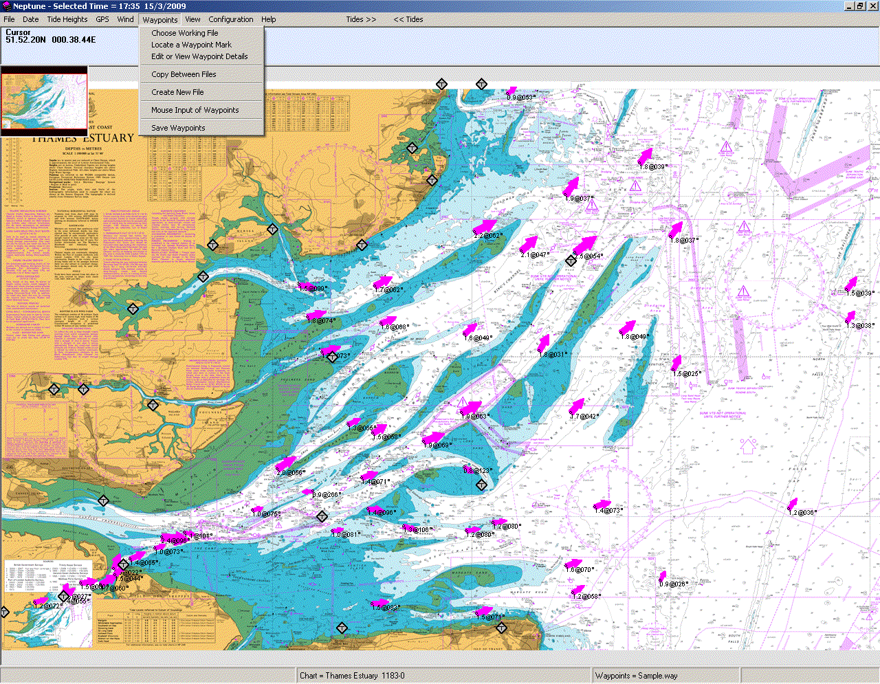
Getting back to the sandbanks, I did a bit of research before I sketched those bits in, going online and looking for Real World examples. I think I have found a good one in the Thames Estuary, as shown below:


Note the scale. It is in Nautical Miles. A quick Google search reveals that 1 Nautical Mile is 1.852 Kilometers, or 1.15078 Miles. Then look at the map of the estuary again. Some of those sandbanks are 10 NM long! Those are the areas exposed at low tide. The second picture was an experiment I did, rotating it and imagining it as the Mssúma river. I've done quite a lot of research on the estuary, checking out old sailing books in my father's collection and the website of the local Sailing Association. The site for Land Information New Zealand provided some useful background about tides. And also a nifty chart showing the relative water levels of each tidal condition, if that is the right word, as well as a glossary of terms

If you review the information you will see that the situation is, as they say, fluid. ;-) Once or twice a day - and that is a topic in and of itself - the tide come in and then go out again, hiding and exposing wide expanses of sand. And keep in mind that Tékumel has two moons which must complicate the situation even more. And then add in the seasonal rains and floods and one realizes that much of the land around the Gulf of Perudáya must be very changeable in nature, at least on the western shore where lie the Tsechélnu Flats, and the north shore which forms the Mssúma river delta. The eastern shores have a different character, as shown by the green used for them on the Swords and Glory map.


Progress so far...

Saturday, November 22, 2014

U Bien Bridge, Myanmar (or Burma, if you prefer...)


There is a blemish on the Swords and Glory map, on the line between hexes 3013 and 2914, an ink smudge that I have chosen to interpret as a series of lakes. :-)


My assumption is that these shallow lakes change in water level throughout the year. I assume the sakbe road that runs across them is similar to that that runs down to Penom or to Purdimal. That is, it is of wood supported upon piles.


Where the U Bien Bridge comes into the picture is I think the local communities are linked to the road and to each other by similar bridges. U Bien bridge is located in Myanmar and is about 1.2 km long, crossing a large lake. It was built in the 1800's from teak logs from a palace that was being abandoned. 


Shown below are some of the screenshots showing some mapping progress. These are actually 3-4 weeks old and I have progressed beyond this point in certain aspects. They show the shallow lakes plus the "Chega Lakes" which I invented to account for the winding path of the unfinished sakbe road that runs south from Hauma. They also show my attempts to locate the village of Nisuel and Jikutlar fief, which appear in one of the solo game books. IIRC, Nisuel is the seat of the Golden Sunburst Clan. In the game book it is stated to be 100 tsan north of Jakalla and Jikutlar fief is located over a 100 tsan further north than that. Which places it approximately where I have drawn it. I'm not sure if that is what was intended as it is stated as being within the Mssuma river delta, which it is not. If it were located two hexes north I think it would be but even though a hex is 100 tsan across, that is not the same as being a full 200 tsan to the North!


Thursday, November 20, 2014

Great Crossbows, Batman!


Plastic Ballista by Eccentric Miniatures (partially built).

One of the great finds I came away from "Fall In!" with was a couple of packages of Eccentric Miniatures' "Great Crossbows". (Thanks, Bill, for pointing them out to me!)

These are plastic kits, sold 2 to a pack for $10 US.


I've started putting one together and have posed it with some of our Serqu figures. As you can see, it scales quite well with our stuff. Technically we don't have any artillery crew figures yet but I think the Serqu figures shown have possibilities. The figures are the three spear poses plus one of the archer poses. My idea is to leave off the plumes (and probably fill in the little dimple at the back of the helm). The plan with the archer figure is to cut away his bow and substitute a bolt from one of the sprues in the kit. He has a quiver of arrows - which is separate - though the straps are present. I think I am up to sculpting a replacement quiver using more of those loose bolts from the sprue. 

I asked at the stand about the possibilities of catapults, and they said that a Trebuchet was being worked on. If they do that, then hopefully and onager or mangonel of some sort will follow. And I've mentioned siege engines to them as well - battering rams and towers, and the like. The kit goes together easily with very little fuss. I used GW's "thin" glue to fix the parts together. The bases are 50mm MDF from Gale Force Nine (bought "by the pint" at a previous convention.)

The scale is right. The price is right. What more can one ask for?

Saturday, November 15, 2014

Thráya


Map by John Till (w. Rachel Kronick) based upon Professor Barker's original.

John Till has started a series of posts about Thráya over on his Fate of Tékumel Blog

I've inserted into the map I'm making and scaled it - somewhat arbitrarily - so that the distance between the two end towers of the south wall was 3 kilometers. This seems to look OK next to the other cities I've inserted. When I checked the width of the river the narrowest section comes in at around 50 meters, which I think is in keeping with the comments Professor Barker made about the Ranánga river on the Blue Room mailing list. 

And today I was flipping through my copy of the Deeds Ever-Glorious (that is, the histories of the Tsolyáni legions, available from RPGNow.com - and well worth the price!) I discovered an interesting reference under the Legion of Chegárra, the Hero-King. 

Actually, I think Thráya is mentioned several times throughout the histories. That book truely is a "must have" for Tékumel fans. There is loads of non-military information included and I found it gives a good insight into how things "work" in Tsolyánu.