Béy Sü - "the Soul of the World", Illustration by MAR Barker
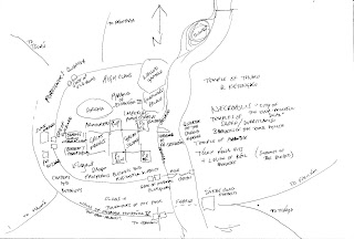
There are text descriptions in the first of the Adventures on Tékumel solo books (blue cover) and in the Man of Gold novel. Based upon the description in the solo book I did the following sketch map, trying to reconcile the text with the EPT box illustration.
Sketch by PHF
The box art doesn't show the outer ring wall, that of Emperor Hejjéka V, the "open-handed", but it could easily just be out of frame to the South. I have taken the southern-most bastion on the eastern side of the river to be a sákbe road fortress at the entrance to the two roads leading to Fasiltúm and Thráya. The box art doesn't show the wall to the north of the city either leading to the question whether it extends all the way around. The wall shown in the art is undoubtedly Patyél’s mighty wall.
In this sketch I assumed that the central citadel is the Governor's palace with the "walled gardens" beyond. This arrangement appears to differ from the Man of Gold text, which places the Governor's palace north of the city and surrounded by gardens. Looking at the box art there certainly seems to be a forested patch immediately north of the city. Could this be the southern part of the Governor's vast gardens? Perhaps the citadel that dominates the central part of Béy Sü in the box art is not the governor's palace at all, and that ediface is an even more imposing structure not shown? Could it be that the fortress shown is the "Pyramid of Ssirandár III"? The Professor was well known for using terms in unconventional manners - his use of the word "pyramid" is not meant to connotate to that used to house Egypt's Pharoahs and he frequently uses the terms "many-legged serpent" and "worm" to describe things that are neither snakes nor worms!
There seems to be an island just north of the walled gardens. Presumably part of the Governor's palace gardens as no structures are shown, though admittedly they could be out of frame to the north. Possibly the location of another Imperial Prison - Jakálla has many prisons, why not the capital?
The descriptions I have found [are there others?] are missing some locations: the Foreigner's Quarter, for one; and the numerous barracks for the other legions headquartered in the city; also the other temples. The Man of Gold text seems to indicate that the Temple of Thúmis - the Temple of Eternal Knowing - is within the city and not on the eastern bank as stated in the solo game book description. Possibly there are two temples, or perhaps it is just a temple to Lord Keténgku, the cohort of Thúmis. To me, it does make sense for the temple of Keténgku to be located out of the city. I imagine it to be a Great Hospital, if the Tsolyáni have such things(?), located away from the stink and contamination of the city.
There are two, possibly three other gates not shown - at least, there are three other sákbe roads: to Haumá in the south-west, to Tsurú in the north-west and to Avanthár in the north.
The gate in the outer wall used in the solo book (the road to Usenánu) is also not named.
From the text of the solo book description one can determine that the sákbe road "faces" west - that is, its high side looks to the west, with its low side facing the river. This is known because the text describes the character being able to see the sákbe roads on the opposite shore and this would only be possible from the upper parapet otherwise. As that level is reserved for the guards, high officials and imperial messengers, the low side must face the river. There is no indication how the other roads are aligned, but I suspect that the southbound road to Thráya faces the river, while that to Fasiltúm faces to the south-east. The northern road to Avanthár [I think] would face west, the road to Tsurú, south-west and that to Haumá south. This assumes Mu'ugalavyá to be the greatest threat and thus the one they would be facing towards.
To be continued...
To be continued...


No comments:
Post a Comment