Friday, December 12, 2014

The Nyélmeyal - the River of Dreams - Digitizing Tékumel, Part 14


The Nyélmeyal River

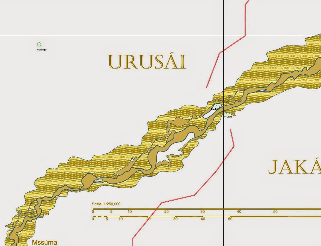
Today's post follows closely on from yesterday and my supposition that the Mssúma River has not always flowed into the Gulf of Perudáya. Assuming that this was indeed the case and that the First Imperium city of Ngála was located on the banks of the river - both highly speculative (but fun) assumptions - what would the river have looked like? Or, more importantly, what does it look like during our current epoch?

The above drawing shows part of my initial attempts. I have even come up with a name - the Nyélmeyal - which I'm fairly certain hasn't been used before. The word "Nyélmeyal" translates as "dreams", making it the "River of Dreams". As it now flows languidly by the ruins of ancient Ngála through the jungles and swamps of what I take to be one of the wilder parts of the Tsechélnu Flats I think the name is fitting. 

Nowadays the ruins are mainly used for demon-related rituals of the temple of Hriháyal. I think the best route for the priestesses would be to take a ferry over to Ngálar Déka from Jakálla and then follow the sákbe road north until it crosses the Nyélmeyal river. At that point I assume there would be a temple and a landing with boats to convey the groups down river to Ngála. Far better than trekking overland through the swamps!

I had a bit of difficulty doing screenshots because the orientation of the area doesn't fit the landscape monitor I use. At least, not at the zoom level I wanted.

So here are two PDF files...


Please let me know if you have any issues with these files. 

Nisuél is stated to be the headquarters or seat of the Clan of the Golden Sunburst, which rose to prominence during the Empire of Éngsvan hla Gánga, that of the Priest-Kings, long before the current empire existed. The area around the village is stated in the green solo book to be "crisscrossed with canals and secondary roads" all of which have yet to be drawn in. My speculation is that in ages past the Mssúma river flowed past Nisuél and joined with what is now called the Nyélmeyal river to reach the sea to the west of Point Kuné. What caused it to change course - assuming you accept this supposition - is unknown, but it might possibly be assumed to have occurred as a result of the cataclysm that sank part of the island of Gánga, drowning the capital of the Priest-Kings empire. 

Thursday, December 11, 2014

Ngála - Digitizing Tékumel, Part 13


The ruined city of Ngála originally dates from the First Imperium, which flourished some fifteen millennium  prior to the current time. It is located in what is now the Tsechélnu Flats. Did the flats exist back then? That is three thousand years before Éngsvan hla Gánga and almost thirteen millennium before the cataclysm that ended that Empire. Personally I think that the flats are a byproduct of that seismic event. I'm not sure if this is stated anywhere though.

The reason I bring this up is because it occurred to me today that the Mssúma River might not have always flowed into the Gulf of Perudáya. I know that the Indus river changed its path as the result of an earthquake. Why not the Mssúma River?

It seems reasonable to me that if Ngála is one of Queen Nayári's, "gleaming cities of the South" it is highly likely it would be built on a major watercourse. My speculation is that instead of curving east and then flowing into the gulf, the river instead flowed south west to Ngála and then south to enter the ocean to the west of Point Kuné in hex 2713.


I'm going to do some sketching tomorrow. I have the start of it blocked in, I think, as I rather fancy that Nisuél - seat of the Golden Sunburst Clan IIRC - also has a similar ancient heritage. This is from a period that pre-dates the sákbe roads if I'm not mistaken. 

I need to look at the Indus river for inspiration as to what happens to the old riverbed, only in that example the region is much drier and so might not be entirely appropriate...

Tuesday, December 9, 2014

Thinking about Lake Vejápa. Digitizing Tékumel, Part 12


Meteora, Greece

I've been thinking a bit about the fiefs in the vicinity of  Lake Vejápa, in particular that island I've plonked down in the middle of the lake. I've intentionally made it so that is always an island whereas the others only become islands for 3 or 4 months of the year.

The above picture of the monasteries at Meteora, in Greece, illustrates something of what I am aiming for, only the rock outcrop is an island. On top would be perched a monastery/temple to Lady Avánthe. My assumption is that this temple would administer a fief centered on the lake.

Wednesday, December 3, 2014

Digitizing Tékumel, Part 11 - a first look at Lake Vejápa


Lake Vejápa

Here is that large lake that I showed off yesterday. I've given it a name, stolen from I don't know where. OK, I know where...do you? ;-)

The idea is that the lake is around all year but varies considerably in size. When the rains start the channels flowing from the Mssúma river fill and it starts to grow in size. Then the floods come - some years higher than others - and the lake overflows its banks until some or all of the shaded area is inundated. In many areas the water will not be that deep: waist deep and often less than that, but in the central portion the waters could be many meters deep. The white areas are those areas that generally do not get flooded though when those once-in-a-hundred-year rains come, even those areas may see some flooding.

This area will have small villages or clusters of clan houses dotted all across the floodplain. They will typically be up on mounds above the normal flood level, or will be on the shores where it rarely floods. When the water recedes they plant their crops and reap the benefit of the rich soil the rivers sediment provides.

What is on that island in the center of the lake? A monastery? A shrine? Or perhaps that is where the local fief-holder has his seat? Which makes me wonder again about fiefs? How big should they be?

Tuesday, December 2, 2014

Expanding the Mssúma River Floodplain - Digitizing Tékumel, Part 10


I've tried to line these up so you can see how the river is shaping up in one go. Not sure how it will display in different browsers...

Here I've started expanding the Mssúma river floodplain. It was bothering me that it was so uniform and narrow. I don't think it would be in a real world. So I pushed it back in a few spots, and added areas where the elevation is high enough that they end up as islands when the river is in full flood. Not that they are necessarily "hills" as such, just enough of a rise to avoid the flooding. Of course, this would vary from year to year. I remember reading a bit about the Sikh wars and I seem to recall all the towns and villages being up on mounds or hilltops.

In the bottom picture I've added another lake. This lake is there all year round but during the floods it expands to over 5 or 6 times its size! I've actually gone a bit further than this, sketching in islands and ox-bow lakes as well as secondary channels. I've also started penciling in some lesser tributaries. Hopefully I'll be able to show you these in a day or two.

Part of my reason for adding the lake is to give a reason for the sákbe road to curve to the west like it does. Why wouldn't it go as straight as possible across the river bend? And there are not enough lakes shown on the large maps anyway. What are there - three, maybe four, in the whole map set?

I've also started to think about how fiefs might be distributed in this new terrain, and who owns what. Well, we know the Emperor "owns" everything, but who are the fief-holders. These will include the temples as well as the clans and nobles. I'll have to look up where each province is administered from as well.

Sunday, November 30, 2014

The Mssúma River - Digitizing Tékumel, Part 9


The Mssúma River Delta

Moving on from yesterday's post, here is the Mssúma river delta - still only roughly blocked in. You will notice that I have decided to show the Mssúma in a sandy-yellow rather than the blue normally used for water. It seemed fitting considering that is closer to the colour!

Shown is the "main channel" - keeping in mind that this is changeable over time. Also shown are some secondary channels, also changeable. These are channels that might go dry in the summer but are open for much of the rest of the year. The lighter toned areas represent an approximation of the flood plain. They are just blocked in at the moment and will no doubt be modified. What I did initially was just trace the outer edge of the river as drawn on the Swords and Glory map. When scaled that feature became quite wide. The problem is that is too consistent a width which is a problem especially the closer to the source you get. A more realistic floodplain would, IMO, be narrower closer to the source and have more wider expanses - the river would of course inundate any low-lying areas. I just have to add some more in to make it look less regular.

This drawing also shows the village of Nisuel (lower left), Chokuga village and Jikutlar fief (top). These feature in one of the solo Adventures on Tékumel books.


Another view, showing the shallow lakes I've added...

These lakes, at lower left, are those mentioned in my U Bien Bridge post a few days ago. That line just to the right of them is part of a polygon I drew to attempt to enclose the Mssúma River watershed, which in turn allowed me to estimate its area. The horizontal wavy line is the approximate boundary of the Flats of Tsechélnu. My assumption is that during flood season the river inundates large areas...

Also note that I've been making up names again: Urúra, a village or town near by those lakes.


Moving up river...

Where the sákbe road meets the river I have chosen to place two small towns; in my campaign they are called Métlan and Jáyo. They are meant to be the Tsolyáni equivalent of Buda and Pest. :-)

The outer edges of the so-called floodplain really need to be worked on. I have to add some minor rivers and streams. In the real world I think there would be hundreds of them! Note again the secondary channels that dry up during the hot summer. Note also that there are two that I have drawn distinct from each other. That is because I think they would become dry at different times, the shallower channel drying first.

By a coincidence I was watching BBC World News or Al Jazeera (I think - I suppose it might have been a North American station but I somehow doubt it) earlier this year and they were interviewing the peasant farmers in Pakistan displaced by the flooding. Apparently the government wants to permanently resettle these people but they don't want to leave, despite being routinely displaced. The reason they don't want to leave is that the flooding deposits so much rich sediment that the crops grow really well. Their whole lifestyle is built around temporary homes and the difference this year is just that the flooding was more extensive. 

I think the Mssúma river farmers would be much the same. Their main crops would be grown in the flood plain where the soil is rich. Their main clan houses would be near by the edge of the floodplain or on higher areas within it. If necessary they would build more temporary residences within the plain, possibly on stilts. When the floods come they would move to the main clan houses, and as the waters recede they would move back and plant their crops for the new growing season.


Mssúra

This map moves up river a bit, again showing the main and secondary channels and a roughly blocked in flood plain. Also shown is the village of Mssúra, another of my made up places. My assumption is that the Mssúma river valley is densely populated - perhaps the most densely populated area in Tsolyánu - so there should be lots of towns and villages all along its length. 


Usenánu


What's this? Two additional rivers?!!

Moving north again we come to the city/town/village of Usenánu. I have always thought of it as a city but in the Deeds of the Ever-Glorious it is referred to as a village. Of course, the scribe who wrote that passage might have been writing it at a time when Usenánu was indeed only a village!

The problem is that one expects to have everything set out in stone for the game. The Professor, however, presented his work as actual historical documents so there are bound to be contradictions, or seeming contradictions. Of course, this isn't actually a problem at all; by doing it this way each game master can tailor the world to suit his needs. And it adds an awesome amount of flavour! :-)

At Usenánu the "village/city" thing isn't the only seeming contradiction I encountered. To the best of my knowledge, descriptive references are few and far between. There is the above mentioned reference in the description of the legion raised there, but the only other reference I know about is the text description in the "Growing up on Tékumel" booklet. This is the little booklet that details character generation. In it the male character example is from Usenánu and he provides a short description of the place, giving some names for the main streets and plazas and that sort of thing.

He mentions the sákbe road heading off to the west but fails to mention that it crosses a river even though, based upon the location of the symbol on the map, it should cross the river coming south from Háuma. He does mention docks and - IIRC - a ferry to the east. And he names that river as the Umétla river whereas the Gardasiyal map calls it the Arjáshtra!

So the initial problem is are we referring to the same river with two different names? Not without real world precedence; the Ganges seems to have many names along its length. Or are there two rivers?

My solution is to assume the latter. I assume that the river that flows south from Háuma is the Arjáshtra river, but as it gets wider - and perhaps there are sometimes two channels that entwine about each other - the name Umétla comes into the picture. This name, occurring further south, is given to the wider channel whereas the narrower one retains the name Arjáshtra.  Just north of Usenánu the two diverge and the smaller Arjáshtra continues almost directly south while the wider Umétla flows more to the south-east. At this point the Arjáshtra channel is so insignificant that in the high summer it might completely dry up, so it is no wonder that it does not receive a mention.

On the map shown above I've used the Pála Jakálla city map as a sort of placeholder. I've only tried a rough pencil sketch of the place itself. I don't recall the population range given via the key on the Swords and Glory map. That is, I suppose the next step. I've tried to make the local topography interesting. I assume that the area with the Mssúma river label is prone to flooding which is why the sákbe road does that hook to the north. I also assume that there are ferries across both the Mssúma and Umétla rivers.

Saturday, November 29, 2014

The Gulf of Perudáya


The Gulf of Perudáya (in part)

Here is a close up of the Gulf of Perudáya in the immediate vicinity of Jakálla. I haven't done anything with the sandbanks beyond my initial sketches. I have added a couple of named places. It seems obvious that there must be a village or town at the the end of the sákbe road that is shown to the left in the above picture, and ferry service that runs from it across to Jakálla and back. I have named it "Ngálar Déka"; "Ngálar" is the name of the province on that side of the gulf and "déka" means boat in Tsolyáni, so it is "Ngálar Boat" (or ferry). 

I have also assumed a ferry near the mouth of the Ranánga river which services the secondary road out of Pála Jakálla. I am utilizing a borrowed map of Pála Jakálla and this map has an eastern gate called the "Thráya Gate", presumably because the road leads to Thráya. So that leads me to assume a ferry to get travelers across the Ranánga in order to reach the sákbe road that runs east along roughly the same line as the river. I have decided that this is an old route and so come up with "Pála Dékakh", or "Yesterday's Boat" in Tsolyáni. 

There is a sákbe road that crosses the Ranánga a little further up river. My assumption is that this ferry has been around longer than that one. Note that in both cases we are talking long periods of time, given the age of the Tsolyáni Empire. Also note that the route east of the Thráya Gate, across the ferry and hence onto the eastbound sákbe road is much quicker than following the road north out of Pála Jakálla and around. A canny merchant would know this while a stuffy noble might take the longer route (not that he would be walking!)

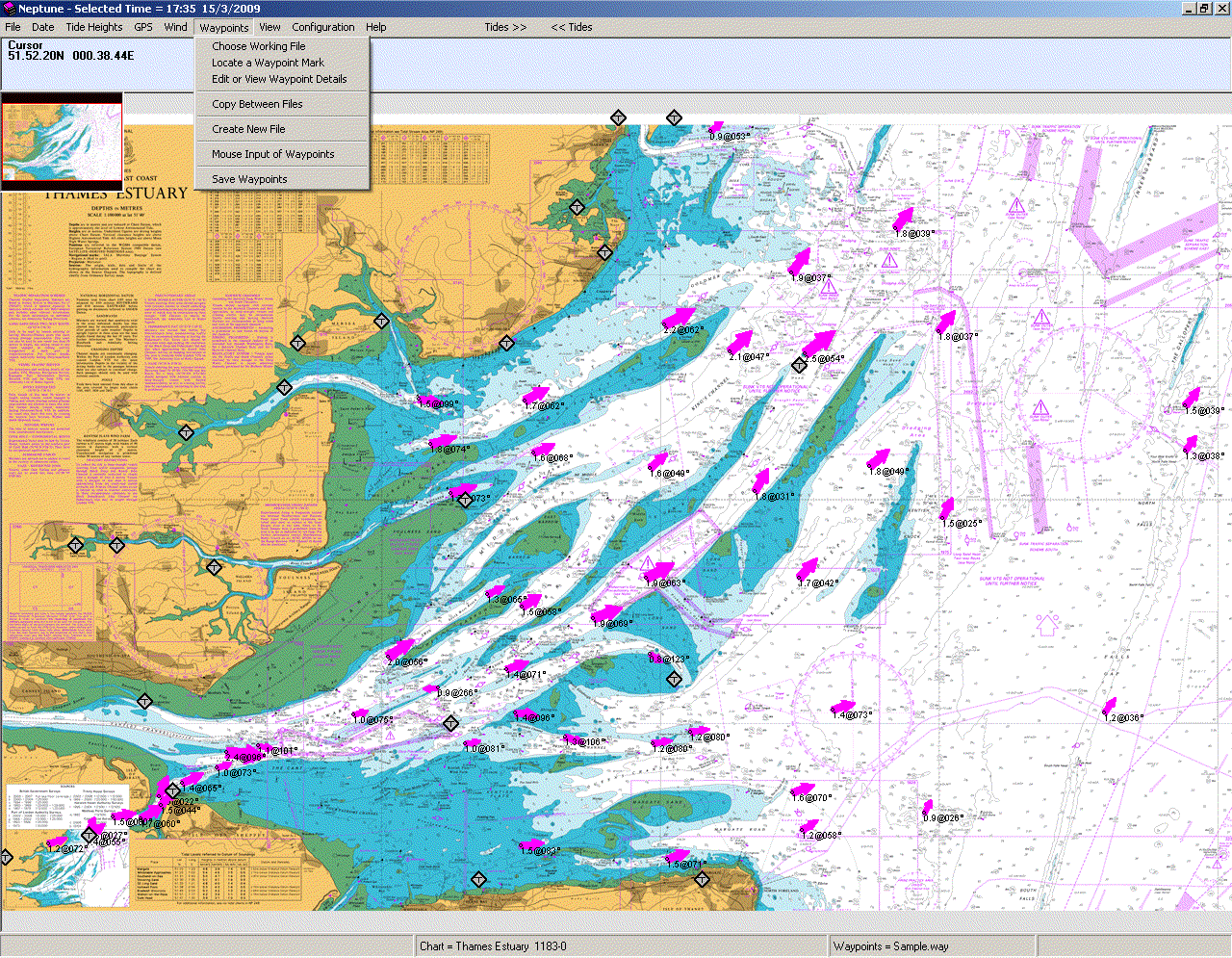
Getting back to the sandbanks, I did a bit of research before I sketched those bits in, going online and looking for Real World examples. I think I have found a good one in the Thames Estuary, as shown below:


Note the scale. It is in Nautical Miles. A quick Google search reveals that 1 Nautical Mile is 1.852 Kilometers, or 1.15078 Miles. Then look at the map of the estuary again. Some of those sandbanks are 10 NM long! Those are the areas exposed at low tide. The second picture was an experiment I did, rotating it and imagining it as the Mssúma river. I've done quite a lot of research on the estuary, checking out old sailing books in my father's collection and the website of the local Sailing Association. The site for Land Information New Zealand provided some useful background about tides. And also a nifty chart showing the relative water levels of each tidal condition, if that is the right word, as well as a glossary of terms

If you review the information you will see that the situation is, as they say, fluid. ;-) Once or twice a day - and that is a topic in and of itself - the tide come in and then go out again, hiding and exposing wide expanses of sand. And keep in mind that Tékumel has two moons which must complicate the situation even more. And then add in the seasonal rains and floods and one realizes that much of the land around the Gulf of Perudáya must be very changeable in nature, at least on the western shore where lie the Tsechélnu Flats, and the north shore which forms the Mssúma river delta. The eastern shores have a different character, as shown by the green used for them on the Swords and Glory map.


Progress so far...