Thursday, September 17, 2015

One of the Good Guys: Eccentric Miniatures...B(u)y The Sprue!


Bucklers, pouches and misc weapons


Longbows


Maces
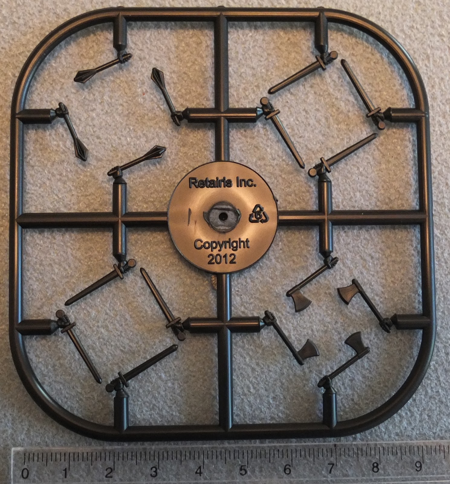

Various Weapons


20mm bases

Eccentric Miniatures is one of my favourite companies. I've gone on about their excellent "Great Crossbows" before - link.

More recently I decided to try their "By the Sprue" range. With the exception of the bases, each of the above sprues cost $2 US. (You get two of the bases sprues in a pack).

The top one is my personal favourite. The bucklers and pouches make it well worth the purchase price. I was considering getting bucklers made, but with this sprue available I can buy them for 25-cents each. Similarly, the pouches will be extremely useful.

Note that the longbow sprue has hands nocking arrows. So if you want to have arrows to stick in shields or the ground in front of your based figures all you have to do is snip the hands off. Note also that there are quivers of arrows but also a couple of bundles of arrows. 

The weapon sprues might be useful for figure conversions. They are a bit plain for Tekumel and the hands are slightly small. One could snip the hands off and just use the weapon, however.

The bases are nice. Straight sides with an indented surface on one side and flat top on the other. The rounded corners may or may not be to your taste.

There are apparently plans to add to the range. A trebuchet was mentioned and I have been lobbying for an onager. :-)  

A possible sprue addition that I think would be very popular would be light and heavy crossbows. One sprue for each. The heavy sprue could have winches to hang from the user's belt. :-)

Tuesday, September 1, 2015

Some Air Cars from my collection...


A non-commercial sculpt. I don't think this
was ever commercially available.


From the Lead Bones range by Recreational Conflict
(There is also a 15mm version that might serve 
as a single person sled.)


Parroom Station - not sure if this is still available.


Also Parroom Station. Available?

(Note that most of the above craft also have fins and railings, etc that are not yet attached.)

I think there has been a tendency to give the Air Cars found on Tékumel a very "hard sci/fi" sort of look. My personal preference is something more elegant or "retro" looking. :-)

My thinking is that there would surely be hundreds if not thousands of different sorts of air cars around: pleasure craft, industrial, military, etc. There would be custom made versions and there would be air cars operated by the various non-human races present on Tékumel. All of these could look quite different from each other.

It is conceivable that none of the surviving Air Cars even resemble each other!


Sunday, August 9, 2015

Digitizing Tékumel, Part 21: More on Appendix '0'...


The above map shows which pages of the report cover which sections of river, including those referenced in my last post.

It is important to remember the differences between the Mssúma and the Nile while trying to decide if there are any similarities. For one, the Mssúma river does not flow through a desert. There is a hot season, to be sure, but the landscape around the river seems to be more like plains with high levels of cultivation. It would have forests - possibly extensive forests - in parts.

If I had a useful description of the Ganges or the Amazon or even the Mississippi - before the US Corps of Engineers did their thing - I would look at that as well. This happens to be the most detailed report on the passage of a large river, and the obstacles faced, that I know about.


The map below shows the areas referenced in the pages immediately above. There is an extra cataract (marked "Upper Gate?") - I'm not sure if it is the gate described in the text or whether it was somehow left out of the report. The distances listed don't seem to fit...


Saturday, August 8, 2015

Digitizing Tékumel, Part 20: Analyzing Appendix '0'


There are many questions about the finer details of M.A.R. Barker's world. How high above sea level does Béy Sü, the Tsolyáni capital, sit for example? I know the city has dockyards bustling with merchant ships but is is all just "clear sailing" all the way to the sea? Its a good 1000 kilometers and probably more - I don't have the time to look it up. Its a good distance!


I know the city sits in the midst of the Beranánga plains. IIRC in "The Man of Gold" the caravan travels "up onto the plain". When one consults the provincial map it appears that Beranánga Province might comprise the entire area of the plains.


I note that the southern border of the province is marked by a long bend in the river. Are the Beranánga plains a plateau?

Presumably there has to be some height difference between Béy Sü and the Sea. Or does there? The northern plains of India through which the Ganges flows do not begin to rise in elevation until very close to the Himalayan Mountains. Is that what the topography of Tsolyánu is like?

All these are questions I have been considering. Of course it doesn't much matter how the Professor envisioned how things looked. He may have considered those details but only a very select audience might have heard the region described. I have to go by published works. And besides, as the Professor said, My Tékumel is bound to be different from His Tékumel.

When I read the description of the first three cataracts on the Nile - Appendix '0' from the Official History of the Sudan Expedition 1884-1885 - I thought this might be useful in understanding what the Mssúma river might look like. Are there cataracts? We know from later published works that the river has a delta but it isn't shown on the maps and earlier works fail to mention it.

I think it would certainly be more interesting if there were cataracts. Borrowing a rule from Gloranthan gamers one could declare there definitely are cataracts because that results in MTF - "More Tékumel Fun"! (MGF = More Gloranthan Fun).

So...in My Tekumel I am thinking there are may be three cataracts. And if you have read Appendix '0' you know a cataract can be comprised of many sets of rapids, not just one. My initial intent is to locate the first cataract a little up river from the towns of Métlan and Jáyo (see previous installments of this thread for details on these towns). The second cataract will be a Usenanu and the third at the river bend marking the border of  Beranánga Province.

Having got that out of the way, below are my notes, page by page, analyzing Appendix '0' and picking out the "useful bits". The bits with extra MTF... :-)


More to follow...

Friday, August 7, 2015

The Sudan Campaign 1884-1885


I was lucky enough to get my hands on a copy of the reprinted Official Report on the Sudan Campaign 1884-1885, ie. the Relief of Gordon. Its quite an interesting read, even though it is largely about logistics. The whole thing seems to have been a logistical nightmare!

For example, after they decided to use whalers to transport the troops up the river it was found that to obtain a large enough number they had to commission them from many different boat builders. The boats were built to the same general specifications and came with masts, oars, sails and rigging, rudders, awnings and various spare parts.

When they arrived in Egypt there was a contractor ready to transport the boats from the transport ships to the railhead. Here they encountered a snag as the contractor declared that his contract was only to move the boats themselves, and not all their accoutrements. Eventually all these bits were put in storage and the boats were moved by themselves.

When the contract was finally amended to include the accessories it was found firstly that some of the equipment had "gone missing", and secondly that the equipment supplied by each manufacturer was designed to fit their boats and not any others! 

A fine pickle one might say!

There were other issues such as the loading platforms at the railhead having to be rebuilt to allow for proper and efficient loading of the trains. The problems just go on and on. Never mind the Mahdi!

My interest at this time is pertaining to the nature of the river before it was altered by dams and other engineering. There are so few unaltered rivers left in the World! I have heard that there is one left in Siberia that has no man-made additions. This account has detailed descriptions of the river and the obstacles presented by the cataracts. First there is Appendix 0 which is a report on the 1st through 3rd cataracts that was prepared as the expedition was being planned. There are also accounts of the trip up the river and back down.

My ultimate goal is to use this information as inspiration for what the Mssúma river might look like in the Tekumel campaign. And if I eventually do any Sudan gaming on the side that is just gravy! :-)

Some of the maps included with the book...


Appendix 0 - pages 141 to 157


Tuesday, July 21, 2015

Digitizing Tékumel, Part 19: a return to the Mssúma river valley...


After a long break, I am starting to look at my "Digitizing Tékumel" project again. Here is another look at the Mssúma river along the border of Urusái and Jakásha provinces. The sákbe road runs south from Usenánu and crosses the river at what, in My Tékumel, I am calling the twin towns of Métlan and Jáyo. Métlan is in Urusái province, while smaller Jáyo is in Jakásha province. For inspiration I am drawing somewhat on the early history of Budapest which was originally two towns on opposite sides of the river.
To the west, Jikutlár fief is visible. This fief features in one of the Solo Gamebooks - the one with the green cover, IIRC. I have located it according to the description in the book: approximately 200 tsán north of Jakálla. The other named places - Anján Wood, Cholúga, Máshtla, Diridé, and Chorkúda - all come from that adventure.
The other two named features - Lake Vejápa and the Abásun River - are my additions. I've stolen the name "Vejápa" from a work of popular science fiction that many may recognize. The word "abásun" means "white" in Tsolyáni, so the Abásun River is the White River. I haven't decided why it is called that yet.
The Abásun River is a dry bed during the hottest months of the year but as the rains come and the Mssúma River rises it flows south into Lake Vejápa. The lake itself gets quite shallow in spots during the summer. Note the small island in the middle. It is possible to wade out to it some summers if one knows the route. When the floods come the Mssúma overflows its banks and the Abásun disappears as the whole area is inundated. Lake Vejápa expands about ten times its original size and neighbouring villages exist as tiny islands or clusters of huts on stilts.