
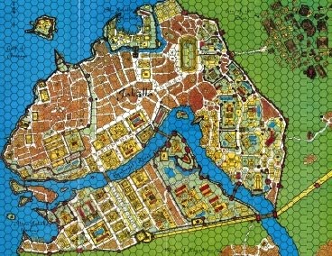
The above screenshot shows a bit of what I have been working on lately. It is taken from the map in the Swords and Glory boxed set and shows part of the Gulf of Perudáya. The hexes shown are 100 tsán across, or 133.33 kilometers. The map symbols show the [theoretical] location of the cities of Jakálla (bottom) and Pála Jakálla (top). The dotted lines mark the lines of the Sákbe roads. The pale yellow area is the Tsechélnu Flats which extend for hundreds of tsán to the west. The green area represents lands with higher elevations than the flats. Three rivers are shown: the great Mssúma river (also spelled Missúma) flows from the north, the Ranánga river flows from the east, and the Eqúnoyel snakes from east to west along the bottom.
What I have done is taken a scan of the Swords and Glory map, or rather a swatch taken from it showing Tsolyánu, and loaded it into AutoCAD. I then scaled the image so that I could draw in meters and kilometers. I should step back and say that I actually started with the city of Jakálla, loading an image of it which is why my units are meters. And technically I can use three decimal places to draw things less than a meter as well.
I then began to digitize both the city and the geography, tracing the maps to do this. Of course, the line representing the coast becomes many kilometers wide when I scaled up the scan so I drew an arbitrary line down the approximate center. I did the same with the rivers and roads. It doesn't really matter right now as I am just blocking things in.
At this point it can be seen that there are problems with the large map. The map symbols for the cities are shown very approximately. Below is the map of Jakálla I used. This is from the original Empire of the Petal Thrones boxed set, and is available from RPGNow for about the cost of a cup of coffee (probably less if you go to Starbucks!)
The river shown is the Eqúnoyel which as you can see flows right through the middle of the city. On the large map, however, Jakálla is shown to the east - about 20-30 kilometers to the east, as a matter of fact!
So some adjustments have to be made.
The above scan of the city should be visible in my digitized image at the mouth of the Eqúnoyel river. I also borrowed a plan of Pála Jakálla that is in the files area of the Tékumel Yahoo group.
I should note at this point that all this is very definitely not canon.
No comments:
Post a Comment