Sunday, April 14, 2013

L is for Lilsú Isle

For such a small piece of real estate we actually know quite a lot about Lilsú isle.

Here is a description by Professor Barker,  quoted from the Blue Room mailing list:

"Lilsú Isle is low, rolling, covered with rather pretty farms and estates
owned by magnates from Jakálla, the Káija Protectorate, and also from
Thayúri Isle. Most of these estates grow garden vegetables, fruits, and
crops for the markets of the other islands and also Jakálla. Nuts,
berries, Dlél-fruit, and other commodities bring in a lot of wealth.
There are only small port towns on Lilsú, too small to be marked on the
map. There is also a central ridge of scrub forest, where a few wild
animals can still be found. The island is about 90 Tsán east-west, by
30 north-south. There are no good all-weather ports, however, and when
storms come, the inhabitants haul their fishing boats and cargo vessels
out of water and put them into protected drydocks. This precludes larger
vessels, of course. There are also dangerous shallow waters and shoals
off the northwest corner of the island, which only a skilled pilot can
avoid. The island is technically under the governorship of Thayúri Isle,
but in fact it tends to be semi-autonomous, run by wealthy landholders
and business folk from Jakálla, Káija, and Thayúri Isle."

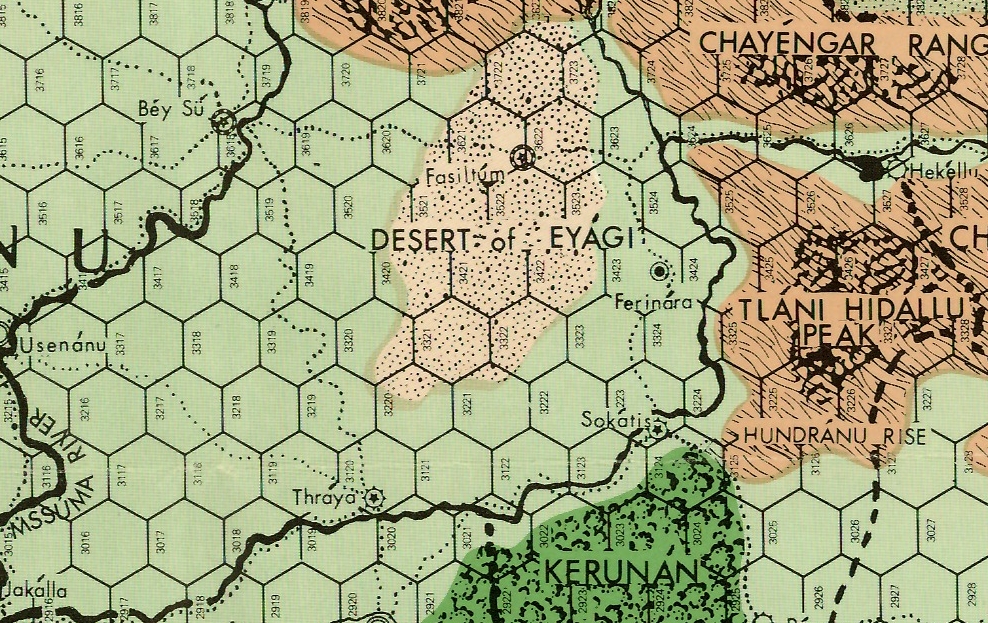
The island can be found on the map snippet in my last post - "K is for Káija and Kerunán".

K is for Káija and Kerunán


Excerpt from original Swords and Glory map, by MAR Barker

The protectorates of Káija and Kerunán are two territories that Tsolyánu seized from Salarvyá in 2029 A.S. and 2031 A.S. respectively, taking advantage of one of that country's intermittent civil wars. That was during the reign of the 55th Emperor, Gyésmu “The Iron Fist”. The current year depends upon when you set your campaign. The original Empire of the Petal Throne game was set about the year 2365 during the reign of Hirkáne Tlakotáni “The Stone Upon Which the Universe Rests”, the 61st Emperor. Subsequent events have advanced the timeline and some set their games during the reign of the 64th Emperor, following the recent  Tsolyáni civil war. Mirusíya Tlakotáni has taken the throne name "Resplendent Flame", in honour of Lord Vimúhla, the God of Fire.

Salarvyá has attempted to retake both protectorates on several occasions, most recently during the civil war, but has never achieved lasting success. Nevertheless, elements of Salarvyáni culture are interwoven with the daily life in the protectorates. The city of Sokátis is said to be "...more typical of a Salarvyáni city: carven gargoyles, ornate parapets, intricate bas-reliefs, and walls which slope up to the ponderous vaults and domes of its roofs." (Swords and Glory, by MAR Barker.)

A.S. = "After the Seal", meaning the "Seal of the Imperium" after the founding of the Second Imperium by the first Tlakotáni Emperor.


Saturday, April 13, 2013

J is for Jaikalór and Jakálla


Excerpt from original Swords and Glory map, by MAR Barker

Jaikalór and Jakálla are two cities on Tsolyánu's southern coast. I've blogged about Jakálla before over on the Tekumel Project blog...over here.

Jaikalór is not the metropolis that Jakálla is, but rather, a small city in Tsolyánu's Káija Protectorate. Both the city and protectorate were once part of Salarvyá and the Ebon Throne still covets them. Salarvyá lies to the south and east, on the far side of the Forest of Gilrayá whose flank the city is nestled under. It is described in Swords and Glory, as "...a flat, faceless town of shops, clacking cloth-looms, and the redolence of timber cut fresh from the Forest...", but with strong defenses built to defend against the non-human Hlutrgú who inhabit the Layóda Swamps.


The Legion of Lord Lángsha of Jaikalór is stationed in the city to provide for its defense.

Wednesday, April 10, 2013

I is for the Isles of the Excellent Dead


Not a physical location as such, but rather a spiritual one.

The Tsolyáni believe that the "Spirit-soul" - or Báletl - one of the Five Selves that make up every person, is the part that completes the final journey after death.

"It is this part of a being which journeys on after death to the Isles of the Excellent Dead and thence to the Farther Shores of the Paradises of Teretané. As it travels, the Spirit-Soul sheds its burden of identity and memory in order to be born anew upon ever more distant planes of consciousness."

The Tékumel Source Book, By MAR Barker

Tuesday, April 9, 2013

H is for Hlíkku, the City of the Mad God


From the Swords and Glory map, by MAR Barker

The city of Hlíkku is a closed city, its inhabitants devotees of the god known as the "Mad One of Hlíkku". The only written description mentions "irregular, curving walls and brown brickwork". Following the dictates of their god the residents wear no clothing within the city walls, except for gold earrings; outside the city they go clad in leather desert cloaks and use bone-tipped spears.

There is some debate over the nature of the entity known as the "Mad One": one of the Greater Demons? Pariah God? Or manifestation of one or more of the other gods? None know for sure, except perhaps the clergy of that city. What is known is that the city is a fertile location for the casting of magic, perhaps due to the presence of the their god; or perhaps the reason he is there in the first place. The priests still speak the ancient language of Tsáqw, a tongue often used for magical texts. 

Monday, April 8, 2013

G is for Gánga


Enterprising locals offer tours of the sunken ruins
of Éngsvan hla Gánga to wealthy Tsolyáni.


Gánga Isle is one of the islands off Tsolyánu's southern coast. In times past it was the seat of Éngsvan hla Gánga, "the Mighty and Powerful Empire"the Empire of the Priest-Kings. When the cataclysm raised up the northern lands (See "D is for Desert of Sighs") the southern coast of  Tsolyánu sank, drowning the capital and heralding the downfall of the empire. The star on the above map marks the location of the sunken ruins. 

F is for Fasíltum, Ferinára and Fénul


Eastern Tsolyánu

Fasíltum, the City of the Chiming Skulls, is the capital of a province of the same name in eastern Tsolyánu. It is a fairly large city located in some hill in the Desert of Eyági; where they get the water for a city of that size is the matter of some debate. Some speak of large cisterns and underground lakes below the city. Or perhaps aqueducts built into the sákbe roads? 

The city is the seat of the Vríddi clan, worshippers of Vimúhla, the Lord of Fire. The appellation comes from their practice of hanging the skulls of those executed from the battlements of the city walls. Here is a better post about the city over at Chirine's Workbench.

In contrast, Ferinára is merely a small town. As far as I know its only claim to fame is being the site of two slave revolts in the last century. Note that slavery is legal in Tsolyánu, being a common punishment for criminals and debtors - the other penalty typically being impalement. (Justice is swift and painful in Tsolyánu!) 

Another town, little Fénul, is just off the map clip to the east. A dusty frontier town, the word "fénul" means "where?" in the Tsolyáni language. You may well ask! ;-)

Sunday, April 7, 2013

E is for the Empire of the Petal Throne


The Empire of the Petal Throne, often abbreviated as EPT, is a role-playing game created by Professor MAR Barker way back in the early nineteen seventies of the millennium just past. It was published by TSR a little after Dungeons and Dragons. Tékumel is the planet on which the game takes place. Tsolyánu is the proper name for the Empire of the Petal Throne, a vast empire larger than modern day Europe that is ruled over by a God-King. The box cover is shown above. It depicts the city of Béy Sü, the capital of the Empire. My previous posts on Béy Sü can be found here...

Saturday, April 6, 2013

D is for Duh!

I noticed afterwards that I used the Desert of Sigh for my "D" post last year as well! Doh!

You can find that post here...

Thursday, April 4, 2013

D is for the Desert of Sighs


Excerpt from the Swords and Glory map, by MAR Barker
Each hex = 100 tsán (133 km)

The Desert of Sighs is on Tsolyánu's northern border. Here lies Milumanayá, a failed nation split between rival warlords in Pelesár in the west and Sunráya in the east. Nomadic tribes roam the wastes in between. Fiercely democratic, the tribes vote before undertaking any major action or decision - even the children are allowed a vote! The hapless traveler lost in the wastes might find their fate being put to a vote: whether given food and water or slain outright, the majority vote decides.

Beyond the desert lies Yán Kór, with the little nation of Pijéna to the west and Saá Allaqí to the east. Ages past this whole area was submerged as a shallow sea but a great cataclysm raised up the land. The Desert of Sighs is littered with old ruins that hint at the location of the old coastline. The red dot marks the "Harbor of Dusty Stones" - the site of an ancient coastal city. The red squares mark other ruined cities, that to the east also formerly on the coast. The red line marks the approximate line of an old Sákbe* road that followed the coast. This information comes from the Northwest Frontier Map Set, by Thomas Thompson and MAR Barker. Unfortunately, the gazetteer only covers the western end of the desert and so the full extent of the coast is unknown.

*a Sákbe road is a multi-tiered combination of road and great wall. Think "Great Wall of China" but with three levels. The lowest is wide and built for the common traffic; the middle level is for nobles and high ranking officials and the upper level is for Imperial Messengers and the like. The highest level is always built facing the frontier of the Empire. There are towers at regular intervals and fortresses at major cities. A model of a Sákbe road can be seen here. It is scaled for 28mm figures - the whole model is over 15' long.

The model was built as a special commission by Chris the Model-maker.

Wednesday, April 3, 2013

C is for Chéne Hó


Excerpted from the Gazetteer for the Northwest Frontier Map Set,
by Thomas Thompson and MAR Barker

Chéne Hó is a province and city in North Western Tsolyánu, south of the Átkolel Heights (see the letter "A" post from the two days ago.) It is described as having several walls, each inner wall higher than the last. How many walls is not stated. The Governor's Palace, major government buildings and the temples are within the innermost ring, as are the clanhouses of highest status clans and merchants. The other rings hold the clanhouses of the lesser clans, the markets and shops, descending in status towards the outer ring. The Foreigner's Quarter is located in the outer ring. While Tsolyánu in general tends to be hot, the climate in  Chéne Hó is "temperate", with only the summer months becoming very hot. I remember Professor Barker once describing it as somewhat like Montana...


Source: http://mamtapatel.wordpress.com/montana/

I take that to mean rolling hills and grasslands similar to the picture above. The only significant mountains however would be the Átkolel Heights and the low Chákan mountains to the Southwest

Tuesday, April 2, 2013

B is for Berenánga


Central Tsolyánu,
excerpted from the original Swords & Glory map,
by MAR Barker

The Beranánga plains to be precise. These are the wide, fertile plains that span central  Tsolyánu from the Kúrt Hills to the Desert of Eyági.  Note that each hex is 100 tsán (133 km) across. Here are two images of the plains of India and Nepal that I am sure would have inspired Professor Barker...


Source: http://www.downtheroad.org/India-Nepal-Subcontinent/Bicycle_touring_pictures/4Terai_Nepal/1Mahendranagar_Border_Pokhara_Terai_Nepal.htm

Monday, April 1, 2013

A is for the Átkolel Heights

The Átkolel Heights

Located in the North Western corner of Tsolyánu, the Átkolel Heights, are the most distinctive geographic feature of the area. The heights are the the remains of the cone of a gigantic volcano, dormant eons past. They are surrounded by steep cliffs on eastern, western and southern sides while in the north the feature slopes gently down to the surrounding landscape. The caldera of the volcano is now a lush valley with forests and lakes. The cliffs are largely inaccessible but for a cleft on the southern face known as Júmre's Ladder, a series of ledges that provide access of a sorts.

Note that the map scan is from the original Swords and Glory map, by MAR Barker, published by Gamescience in the early 1980's.